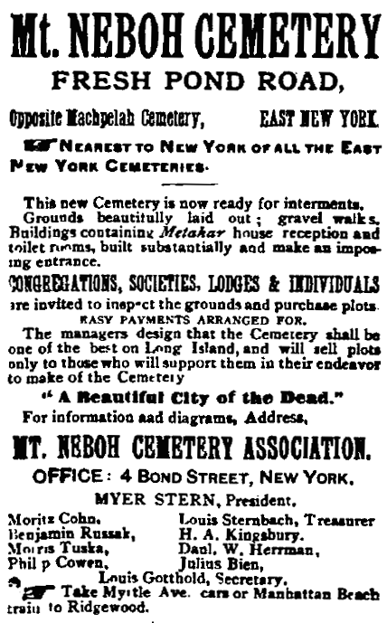
An 1889 ad for Mount Neboh Cemetery, from a Jewish newspaper published in New York City (The American Hebrew, Jan 4 1889)
Mount Neboh is one of several Jewish cemeteries clustered near the Brooklyn-Queens border in Glendale, Queens. Founded in 1886 by Mount Neboh Cemetery Association, this 14-acre cemetery is located on the east side of Cypress Hills Street between Cooper Avenue and Jackie Robinson Parkway and is flanked by the old and new sections of Mount Carmel Cemetery. Although its grounds are a bit timeworn today, Mount Neboh was considered one of the foremost Jewish cemeteries in New York at the turn of the century. An impressive sight is still provided by the two circular rows of fine mausoleums that stand just past the entrance, forming the nexus of the cemetery’s layout.
U.S. Congressmen Emanuel Celler and William Wolfe Cohen are among the approximately 15,000 individuals laid to rest here. Mount Neboh Cemetery also was the original place of interment for Sholem Aleichem, the beloved Yiddish writer whose stories inspired the musical “Fiddler on the Roof.” Sholem Aleichem was buried at Mount Neboh upon his death in 1916 with the intention of returning his body to Russia after the end of World War I, but in 1921 he was permanently interred in a grave at neighboring Mount Carmel Cemetery.
Mount Neboh Cemetery in 1903, located on the east side of Fresh Pond Road (now Cypress Hills Street) (Hyde 1903)Mount Neboh Cemetery today, situated between the old and new sections of Mount Carmel Cemetery (NYCityMap)Mount Neboh Cemetery (NYCityMap)A polished black granite tombstone with etched portraits, a style favored by recent Jewish immigrants from the former Soviet Union, stands among older monuments in Mount Neboh Cemetery (Mary French)
A view of Southside Burial Ground, Nov 1927 (QBPL)
In a 1934 article in the Leader-Observer, a longtime resident of Ozone Park described the area’s old community burying ground, remnants of which still exist at present-day Redding Street, Albert Road, and 149th Avenue in Queens:
In a little-known and seldom-visited corner of Ozone Park is one of the oldest burying grounds in New York . . . 15 years ago I often walked out there with my son, who was then a youngster, and we would wander about, reading the inscriptions on the stones and listening to the music of the birds that made the place their home. In those days there were only a very few houses near it . . . The plot even then had long been neglected, but without the usual sad results of neglect. Without man to spoil, nature ran riot . . . in the summer time the whole place was a glorious profusion of violets, lilies of the valley, tiger lilies, and even roses. To this little paradise had repaired the birds that had gradually been chased out of the more settled sections, so that in a few minutes the casual visitor would see ten or a dozen different varieties of brilliant multi-colored songsters . . . Taken all in all, it seemed to me then the most fitting resting place for those pioneers of old I had yet seen . . . The names on these ancient . . . stones were almost all Dutch, names that today are well known. Vanderveers lay there, and Van Wycks along with many others who gave meaning to the wilderness that once was this part of the country.
Today all is changed. I walked out there a few days ago, for the first time in about 10 years, and I was shocked. Since that time the Crossbay boulevard has been laid; a big cash-and-carry supermarket stands nearby; a development company has hedged in the little burying ground with raucously new brick houses. Where the birds used to sing by the old pipe line, autos now roar by in an unending stream on the Sunrise highway. But what shocked me most was the condition of the cemetery itself. The birds are gone, and the flowers. The shrubbery that once gave the moss-covered stones a decent privacy are now but a bedraggled collection of broken weeds. Even the stones are gone. Where they went I do not know . . . Of the several hundred monuments that were standing ten years ago, not more than a dozen remain . . .
The Southside Burial Ground in 1849, situated near the junction of the Old South Road and the Road to Jamaica BayThe Southside Burial Ground in 1919 (Queens Topographical Bureau).
This community cemetery was set aside as a burying ground about 1680 and was situated at the junction of two colonial highways—the Old South Road that crossed southern Queens from east to west, and the Road to Jamaica Bay, which later became Woodhaven Boulevard. Each neighboring family, among them the Ryders, Van Wicklens, Durlands, and Stoothoffs, was allotted a share in the burial ground at the time it was established. Known today as the Southside Burial Ground, the old graveyard has been referred to by a number of names over the years, including the Van Wicklen Cemetery, Aqueduct Cemetery, and Homestead Cemetery. The half-acre burial ground was used and remained intact until the housing boom and street construction that began in the 1920s destroyed much of it. About half of the cemetery was lost when 149th Avenue was extended through the southern portion of the site, and most of the monuments had disappeared by the 1930s.
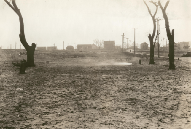
In December 1935, Long Island Daily Press reporter Sarah Wilford called the Southside cemetery the “most desolate in Queens,” after workmen chopped down most of the trees at the site and burned it over to clear it of vegetation. What remained of the cemetery gradually became a dumping ground. Concerned citizens of the area fought for decades to protect and preserve the burial ground, and today the NYC Parks department manages the site. Four gravestones still exist in the northern section of the old graveyard, which remains on the east side of Redding Street, between Albert Road and 149th Avenue. A remnant of the southern portion of the cemetery also exists in the park on the other side of 149th Avenue; although no stones are present in this section, it is distinguished by a chain-link fence that separates it from the adjacent ball field.
The “desolate” Southside Burial Ground in Jan 1936, after it was burned to clear it of vegetation (QBPL)The Southside Burial Ground today (NYCityMap)Tombstones in the northern section of the Southside Burial Ground. (Mary French)Remnant of the southern portion of the Southside Burial Ground, adjacent to Vito Locascio Field (formerly Loring Field). (Mary French)
Sources: Description of Private and Family Cemeteries in the Borough of Queens (Powell & Meigs 1932), 54-57; Sidney’sMap of Twelve Miles around New-York, 1849; The Story of Woodhaven and Ozone Park (Seyfried 1985), 119; “Ozone Park Burial Ground Has Rich History,” Leader-Observer, Jan 4, 1996; “LIer Fights to Get Cemetery Removed from City Tax Rolls,” LI Press, July 2, 1972; “Historic Tombstones Found,” The Forum, Nov. 23, 1985; “South Side Cemetery Most Desolate in Queens,” LI Daily Press, Dec 12, 1935; “Crossbay Blvd Wipes Out Old Burying Ground,” Leader-Observer, Nov. 22, 1934; NYCityMap.
Situated in the middle of a blockful of buildings at 96th Street and Jamaica Avenue in Woodhaven, Queens, the Wyckoff-Snediker Cemetery is a relic of the area’s early history. The 85 x 266 foot tract is named for two families of Dutch descent who, around 1785, set aside equal portions of their adjoining farms for a local burying ground. About 200 area residents, including members of the Lott, Eldert, Suydam, Snedeker, and Wyckoff families, were buried there until it ceased to be used in the late 1800s.
Location of the Wyckoff-Snediker Cemetery (NYCityMap)
Abandoned as descendants of the old families died out or moved away, the Wyckoff-Snediker Cemetery became neglected and dilapidated during the early 20th century. In 1901, St. Matthew’s Episcopal Church was built on 96th Street, abutting the west side of the cemetery, and single-family homes and other buildings gradually surrounded the remainder of the graveyard. A 421-foot path from Jamaica Avenue, a perpetual right-of-way to the burying ground, transformed into an alley lined with garages. In 1962, St. Matthew’s Church purchased the cemetery for $500 at city auction after it had been seized for non-payment of taxes. Members of the parish, along with volunteers from the Queens Historical Society and Woodhaven Historical Society, have worked to restore the site, periodically clearing it of growth and debris and righting toppled tombstones. Around 100 gravestones are still present in the cemetery today, ranging from early fieldstone and brownstone markers to later marble and granite monuments. About 30 trees, all over 100 years old, also remain, adding to the bucolic atmosphere of the old graveyard.
The Wyckoff-Snediker Cemetery in 1912 (Hyde 1912)Tombstones in the Wyckoff-Snediker Cemetery. (Mary French)
Sources: Description of Private and Family Cemeteries in the Borough of Queens (Powell & Meigs 1932), 48-53; The Story of Woodhaven and Ozone Park (Seyfried 1985), 9; “Children Play Among Gravestones,” Long Island Daily Press, Sept. 18, 1935; “Two Old Cemeteries Auctioned Off by City,” Long Island Star Journal, Feb. 9, 1962; “A Cemetery in Woodhaven,” Leader-Observer, Oct. 31, 1974; “The Dead of New York,” The Economist, Jan. 18, 2008; Hyde’s 1912 Atlas of the Borough of Queens 1:Pl. 4; NYCityMap.