Tag Archives: family cemeteries

Bergen Family Burial Ground

The Bergen family burial ground shown on an 1850s map.

In June of 1874, there was great excitement in the Brooklyn neighborhood now known as Sunset Park when a police officer named George Zundt uncovered human remains while excavating for a cesspool at the home he had recently moved into on 40th Street between Third and Fourth Avenues. Among the remains, which included two skulls (“to which hair still adheres,” a local newspaper reported) and other bones, Officer Zundt found a coffin plate with the following inscription: “Catharine Crabb, Aged 71, Died March 17, 1839.”

A photo of the DeHart-Bergen House that stood just west of the Bergen family burial ground near Gowanus Bay, taken before the building was demolished in 1891 (NYPL)

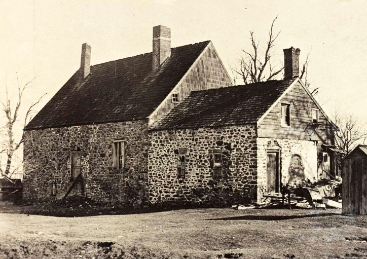
It turned out that Zundt’s new home was on the site of an old burial ground that had been part of the homestead farm of Simon Bergen (1768-1830). A descendant of one of the area’s earliest Dutch settlers, Simon Bergen owned the northeasterly half of what had once been the 300-acre DeHart plantation near Gowanus Bay. Bergen’s father, also named Simon Bergen (1746-1777), and his grandfather, Johannes Bergen (1721-1786), each married members of the DeHart family, and thus the DeHart farm came to be owned by the Bergens. After the untimely demise of the elder Simon Bergen at age 31 (from wounds inflicted by a misfired musket he was considering purchasing) the farm was divided between his sons Simon and John. Simon retained that portion of the property that included the DeHart-Bergen House. Built in the 1670s, the DeHart-Bergen House stood west of Third Avenue near 37th Street, overlooking Gowanus Bay.

The Bergen family burial ground and surrounding farmland on an 1850s property map covering that area of modern-day Sunset Park

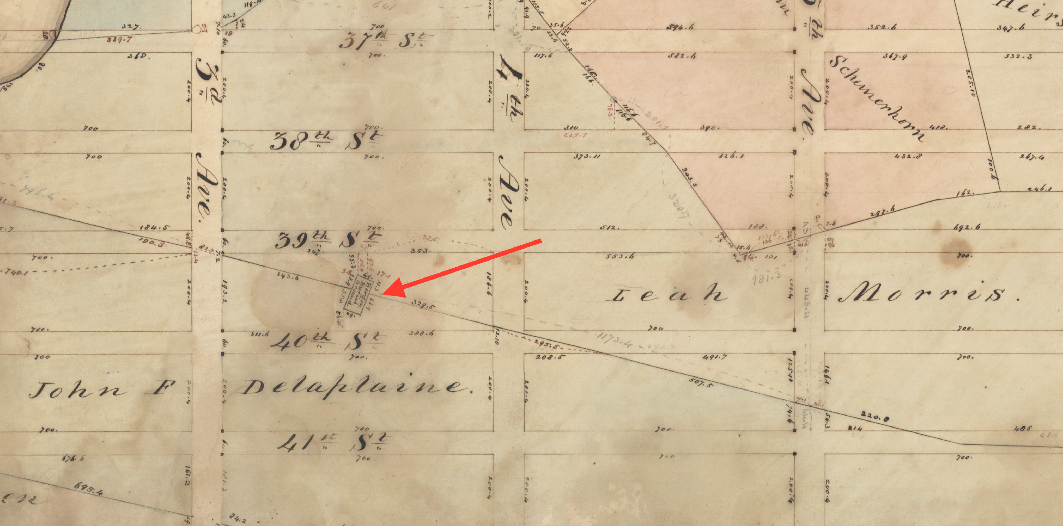
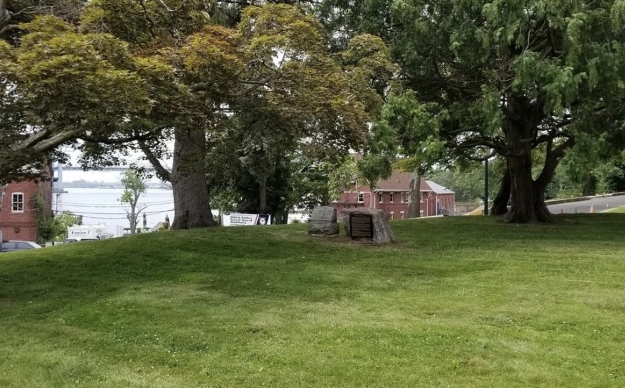
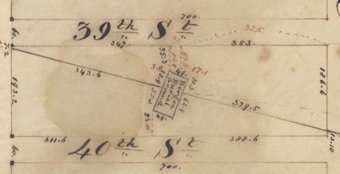
Just east of the ancient DeHart-Bergen House was the Bergen family burial ground, situated in the middle of the block bounded by 39th and 40th Streets and Third and Fourth Avenues. Several 19th-century property maps and land records define the cemetery, which was “forty-nine feet from north to south and ninety-four feet from east to west” and surrounded by a stone wall. In an 1827 deed, Simon Bergen conveyed the plot to John S. Bergen, Jacob Bergen, Peter Bergen, Cornelius Bergen, Theodorus Bergen, Leffert Bergen, Garret Bergen, and John T. Bergen, and their descendants, for burial purposes forever, and reserved the perpetual right for burial for himself and his descendants.

The homestead burial ground was probably used from the late 1700s until the 1840s when Bergen descendants began to move the remains of their family members to plots at nearby Greenwood Cemetery. After Simon Bergen’s death, his farm was divided between his daughters Leah Morris and Gashe Lott, who sold the land out of the family.

A 1903 map shows redevelopment of the Bergen family burial ground with the former cemetery and old farm lines denoted.

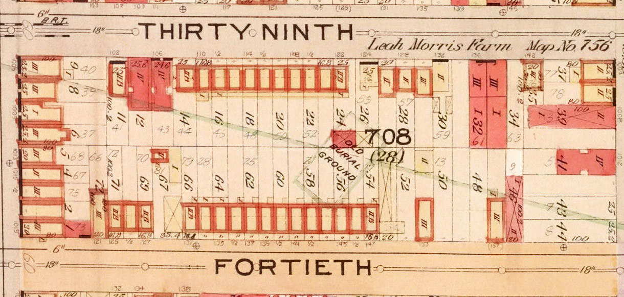
By the late 1860s, most of the remains had been removed from the old Bergen family burial ground, and the property around it had been broken into building lots. The site’s use as a cemetery had not yet been forgotten, however. In 1870, the Brooklyn Daily Eagle reported that local police had visited the old Bergen family burial ground at 39th and 40th Streets to investigate a new grave that had been made at the site without authorization. Finding the fresh mound, officers exhumed a small pine coffin that contained the corpse of an infant only a few days old. Murder was suspected based on contusions found on the infant’s body.

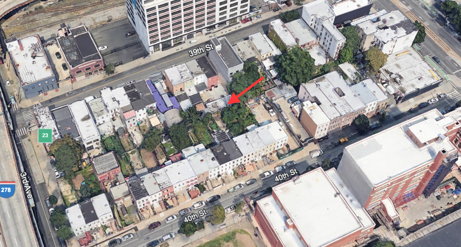
This 1870 mystery is the last that is known of the Bergen family cemetery until after it had been redeveloped and was uncovered again in 1874 by Officer Zundt’s home improvement project. No records have been found to identify the Catharine Crabb whose coffin plate was retrieved among the bones uncovered in 1874, or to explain why she was buried in the Bergen family graveyard. Today, homes still stand on the former site of the Bergen family burial ground.

A 2022 Google Earth satellite view of the former site of the Bergen family burial ground in Sunset Park Brooklyn; arrow denotes approximate location of the site.

Sources: 8th Ward from 26th St. to 42nd St, [185?], Map, Bergen-[185-?]c.Fl; Map Collection, Brooklyn Public Library, Center for Brooklyn History; Hyde 1903 Atlas of the Borough of Brooklyn, Vol 1, Pl 33; Kings County Conveyances, Vol 26 p3-4, “United States, New York Land Records, 1630-1975,” FamilySearch; The Bergen Family; or the Descendants of Hans Hansen Bergen, one of the Early Settlers of New York and Brooklyn, L.I. (Bergen 1876); “Legal Notices,” Brooklyn Daily Eagle, Sep 15, 1864; “Supposed Child-Murder,” Brooklyn Daily Eagle, Feb 14, 1870; “Disturbing the Remains of the Dead,” Brooklyn Times Union, Jun 4, 1874; Prepare for Death and Follow Me:”An Archaeological Survey of the Historic Period Cemeteries of New York City (Meade 2020)

Thorne-Wilkins Cemetery

A view of the Thorne-Wilkins Cemetery in Fort Totten Park, 2019 (Tom Loggia)

Since childhood, brothers Thomas and Vincent Loggia heard family stories about ancestors buried within Fort Totten, the former U.S. Army installation on the Willets Point peninsula in northern Queens. The Willets Point name derives from Charles Willets (1781-1833), who purchased the property in 1829. Before that, the peninsula belonged to the Thorne and Wilkins families. Englishman William Thorne (1617-1664) received the land from the Dutch in 1639, and the farmland remained in his family until 1788 when Ann Thorne married William Wilkins. Thomas and Vincent Loggia are descendants of Ann Thorne and William Wilkins. For many years, evidence of their family’s ancestral burial ground was lost and officials were unaware of its presence within the fort. After 20 years of painstaking research, the Loggia brothers recently proved the existence of the burial ground and had it recognized as the Thorne-Wilkins Cemetery.

An 1860 map shows Wilkins Point (present-day Willets Point), the peninsula where Fort Totten is located today. Arrow denotes approximately location of the Thorne-Wilkins Cemetery.

The Thorne-Wilkins Cemetery is a small plot on a knoll about 500 feet inside the entrance of Fort Totten. A clause in the 1829 deed transferring the land from Jacob Thorne Wilkins to Charles Willets reserves the burial ground for the use of the family; this exception was reiterated in later transfers of the property. Some 30 members of the Thorne-Wilkins family are thought to be buried in the plot. Family progenitor William Thorne—one of the original patentees of Flushing, Queens, and a signer of the 1657 Flushing Remonstrance—may be among those laid to rest here. Exactly who is buried here is unknown—the only documentation of the graves was made by James Thorne, Jr., who visited the burial ground in 1857 and sketched five badly weathered tombstones.  Initials (“I.T.” and “A.T.”) and dates ranging from 1709 to 1775 were all that were visible on the stones.

This detail from an 1865 survey of property transferred to the U.S. government for Fort Totten shows the Thorne-Wilkins Cemetery

Between April 1857 and April 1863, the U.S. government acquired the properties to create Fort Totten, which hosted a series of military services until a large portion of the land, including the cemetery plot, was secured by New York City Parks in 2001. At that time, only one memorial stone stood on the site of the Thorne-Wilkins Cemetery—a monument to Charles Willets, the man who acquired the property from the Thorne-Wilkins family. This marker is somewhat of a historical mystery. Records show that in 1855, the Willets family removed Charles Willets’ remains and his weathered tombstone from his “Flushing farm” to a plot in Greenwood Cemetery in Brooklyn. His original burial place is not actually known; he may or may not have been interred in the Thorne-Wilkins Cemetery.

Descriptions of the Thorne-Wilkins burial ground before the 1930s do not mention Charles Willets’ tombstone at the site, suggesting this marker was placed there sometime in the early 1900s, possibly to commemorate the namesake of Willets Point rather than as an actual gravemarker. Whatever the case may be, the existence of Willets’ marker at the site in the 20th century, along with the lack of any other headstones, contributed to the loss of association of the burial ground with the Thorne-Wilkins family. By the time the property was taken over by the Parks Department, officials did not know of the Thorne-Wilkins burial ground and mistakenly believed that Charles Willets was the only civilian who had ever been interred within the fort’s grounds.

Sketches of tombstones in the Thorne-Wilkins Cemetery, 1857

In 2016, archaeologist Joan Geismar reviewed and analyzed the extensive material that Thomas and Vincent Loggia had amassed and presented it to the Parks Department to support the Loggias’ appeal to have the burial ground formally recognized as the Thorne-Wilkins Cemetery. The request was successful and in 2019, with the full support of NYC Parks and other family members, Thomas and Vincent Loggia installed a one-ton boulder at the site. One side of the massive stone holds a plaque identifying the burial ground and its history; the opposite side has an inscription honoring their seventh great-grandfather, William Thorne.

Asked in a 2012 interview why he persevered in this family quest to seek out and memorialize the lost Thorne-Wilkins burial ground, Thomas Loggia responded: “People should acknowledge things of importance. Maybe nobody will ever go visit them again. But really, that’s not the point. The point is they existed.”

A 2018 aerial view of part of Fort Totten Park; arrow indicates location of the Thorne-Wilkins Cemetery (NYCThen&Now)

Sources: Map of the City of New York and Its Environs (Walling 1860); Map of Survey of Land of Willets Point, Recently Purchased from Henry Day, Esq., by the United States (Trowbridge 1865); “Military and Civil Law Conflict,” New York Times Apr 21, 1895; “Willets Point Graveyard,” Brooklyn Daily Eagle,  Dec 6, 1896; “Whitestone,” Brooklyn Times Union, Apr 26 1902; “Owned Property at Fort Totten,” Daily Star (Queens), Jan 10, 1907; “To Be Sold in Partition,” Brooklyn Daily Eagle,  Apr 4, 1911; “Legendary Tunnel of 1862 Traced at Fort Totten,” Brooklyn Daily Eagle, Jun 17, 1937; “Until an Ancestral Graveyard is Found, No Time to Rest,” New York Times, Jun 1, 2012; Memo Report: Thorne/Wilkins/Willets Cemetery, Fort Totten, Queens (Geismar 2016); “Hidden in Plain Site: The Thorne-Wilkins Burying Ground,” New York Researcher, 28(4), Winter 2017; Thomas Loggia, personal communication, Jan 19, 2023

Moore-Jackson Cemetery

Tombstones in the Moore-Jackson Cemetery in 1925 (NYPL)

Throughout the five boroughs, New Yorkers are actively protecting the forgotten and neglected burial places of their neighborhoods. Some are silent guardians tending to these old plots with little fanfare, while others are vocal advocates striving for preservation. Most have no familial or cultural ties to those interred in the graveyards they caretake and defend but feel called to save these historic sites and honor their departed local forerunners.

For more than 25 years, Ceil Pontecorvo almost single-handedly maintained the Moore-Jackson Cemetery next door to her apartment building on 54th Street in Woodside, Queens. Noticing that the old graveyard had become a neglected dumping ground, she determined that the people buried there “deserve better than this” and began planting flowers and shrubbery, picking up weeds and garbage, and was among those who lobbied the city to landmark the Colonial-era site, which they won in 1997.

At left is a map detail showing location of the Moore-Jackson Cemetery in Woodside, Queens (mid-block between 31st St and 32nd St, the site extends from 51st to 54th St). At right is a 1919 survey showing location of graves at the site.

The Moore-Jackson Cemetery was established by 1733 on the farm of Samuel Moore and Charity Hallett Moore, just north of their homestead on Bowery Bay Road (present-day 51st Street) at the outskirts of the colonial village of Newtown. The Moores were early English settlers of Newtown, played a prominent role in the development of Queens, and intermarried with such leading families as the Rikers, Berriens, Blackwells, and Rapelyes. Among those interred in the cemetery is Nathaniel Moore (d. 1802), the owner of the land during the American Revolution. A staunch loyalist, Nathaniel Moore housed a division of the British Army following its victory at the Battle of Long Island and some say the British capture of Manhattan was planned in the Moore home. A great-granddaughter of Nathaniel’s married into the Jackson family, from which the cemetery and nearby Jackson Heights get their names.

A view of the Moore-Jackson Cemetery in 1927 (NYCMA)

The cemetery remained in active use until at least 1868 and contained at least 51 graves which were marked with fieldstone, brownstone, and marble gravestones. By the early 20th century, most of the Moore descendants had moved away, and the burial ground fell into periods of neglect and rediscovery. In 1998, the last surviving heir of Nathaniel Moore transferred ownership of the site to the Queens Historical Society.

Today, about a dozen headstones still stand at the Moore-Jackson Cemetery and only a few have legible inscriptions. Most of the gravestones are clustered near the side of the property bordering 54th Street and although that section was well kept by Ms. Pontecorvo and others, the rest of the half-acre property, which extends to 51st Street, remained “a jungle” for decades. In 2017, several Woodside residents came together to clean up the overgrown lot and received permission from the Queens Historical Society to create a community garden on part of the property. The cemetery has now entered a new phase of neighborhood guardianship. While the burial area near 54th Street is preserved, the remainder of the site is a vibrant community garden that provides fresh food, green space, and programs for local residents.

A view of tombstones at the Moore-Jackson Cemetery in October 2010. The gravestone in the foreground, commemorating Augustine Moore, is the oldest legible marker at the site today (Mary French)
The aerial view at left shows the Moore-Jackson Cemetery in 2018; at right is a more recent view depicting the raised planting beds and other features of the new community garden at the property (NYCThen&Now/Google)

Sources: Description of Private and Family Cemeteries in the Borough of Queens (Powell & Meigs 1932); Woodside: A Historical Perspective, 1652-1994 (Gregory, 1994); Moore-Jackson Cemetery Designation Report (Landmarks Preservation Commission 1997); Moore-Jackson Cemetery Phase IA Archaeological Assessment Report (Bergoffen 1999); “A Long-Orphaned Family Plot,” New York Times, Jan 19, 1997; “A Hidden Cemetery of an Earlier Era Becomes More Visible,” New York Times, Jul 2, 2000; “Volunteers Want Help Revitalizing Colonial-Era Cemetery in Woodside,” DNAinfo, Oct 11 2017; “Historic Woodside Site Revamped Into Community Garden,” Astoria Post , Jan 14, 2022; Moore-Jackson Cemetery and Community Garden

Cole Family Burial Ground

This detail from an 1853 map of southern Westchester county shows the Charles Darke and William O. Giles farms, properties that previously made up the the Jacob Cole estate. The Cole burial ground and vault was located at the southern end of Charles Darke’s farm.

In the summer of 1895, general contractor Charles W. Collins got a contract with the city for grading part of Boston Road in the Kingsbridge section of the Bronx. His work proceeded smoothly and was almost complete when he encountered an unforeseen obstacle—a small graveyard, about 25 feet square, near what is today the intersection of Albany Crescent and Bailey Avenue. Containing several weather-beaten headstones and a ruined vault, the site was the burial place of between 40 and 50 members of the Cole, Schuyler, and Berrian families of Kingsbridge and Fordham. 

This burial place dated back to about 1820, when carpenter Jacob Cole acquired four acres of land near the junction of what was then Albany Post Road and Boston Post Road. By the 1840s, Jacob Cole’s property encompassed 52 acres between today’s Albany Crescent and West 238th Street. The burial ground, consisting mainly of a vault but with a few separate graves nearby, was situated at the south end of the Cole estate. Jacob Cole died in 1842, and in 1845 his son James and daughter-in-law Catherine sold the southern portion of the estate to Charles Darke, with an exception “reserving the vault for the use of descendants of Jacob Cole, deceased, twenty-two feet by forty feet.” Family members may have continued to use this burial place until the 1860s, afterward acquiring lots at Woodlawn Cemetery.

An 1867 property map (at left) shows the “Cole Grave Yard” on Charles Darke’s property; the 1873 topographical map at right depicts the burial vault.

The old Cole family burial vault, which was built into the slope of a hill and measured about 10 feet wide, 14 feet long, and 9 feet deep, first came to public attention in November of 1892 when heavy rainstorms caused the doorway to collapse and exposed the decayed and crumbling coffins to view. Children playing in the neighborhood discovered the open structure and carried off some of the skulls and bones. Descendants repaired the entrance to guard it against further vandalism, but their efforts would be short-term protection as it was only three years later that the site faced destruction.

When contractor Collins encountered the burial place during his roadway construction in 1895, he made arrangements with the city to remove the remains to St. Michael’s Cemetery in Queens. This plan incurred the wrath of Cornelius B. Schuyler (known as “the man that owns Kingsbridge” according to a New York Tribune article), who threatened to shoot anyone that dared to desecrate the final resting place of his ancestors. Mr. Schuyler was eventually pacified when assured that he could transfer the remains to the Schuyler plot in Woodlawn Cemetery.

On August 20, 1895, Mr. Collins, Mr. Schuyler, and a representative of the Board of Health met at the site to witness the work of the undertakers who removed the remains from the vault and graves. When the vault was opened, they found the stone walls had crumbled and the shelves on which the coffins had been placed had sagged towards the middle of the vault, where there was a pile of bones several feet high. A few coffin plates and a set of false teeth were found, which Mr. Schuyler pocketed. Two headstones marking the graves outside the vault were taken along with the remains to Woodlawn. They bore the names of Jacob Cole and Berrian and were dated 1835. After the removal the vault was demolished; today the site is under the roadbed of Albany Crescent.

A 2018 aerial view of the former site of the Cole family burial ground and vault (NYCThen&Now)

Sources: Map of the southern part of West-Chester County, N.Y. (Dripps 1853); Map of Property Situate in the Town of Yonkers Westchester Co NY belonging to Charles Darke, 1867 (Westchester County Clerk Map #Vol3 PG17); Topographical Map Made from Surveys by the Commissioners of the Department of Public Parks of the City of New York of that part of Westchester County adjacent to the City and County of New York…(Department of Parks 1873); Westchester County Conveyances, Vol 109 p25-27, “United States, New York Land Records, 1630-1975,” FamilySearch; “Skulls as Playthings,” Evening World, Nov 22, 1892; “An Old Burying Vault Disturbed, The Sun Nov 23, 1892; “Fifty in One Coffin,” New York Herald Sep 8, 1895; “An Old Graveyard Torn Up,” New York Tribune, Sep 8 1895; “An Old Graveyard Uncovered,” The Sun Sep 8, 1895; “Skeletons in the Kingsbridge Closet,” Riverdale, Kingsbridge, Spuyten Duyvil…(Tieck 1968); Cemeteries of the Bronx (Raftery 2016); “What Lies Beneath: Cemeteries of the Bronx,” Bronx County Historical Society exhibit, Oct 2017; Prepare for Death and Follow Me:”An Archaeological Survey of the Historic Period Cemeteries of New York City (Meade 2020)

Watt-Pinkney Family Burial Ground

An 1849 map shows Archibald Watt’s Harlem estate

On a June day in 1910, an undertaker and his assistants labored in the drizzling rain to remove coffins from the Watt-Pinkney estate that covered an entire city block between 139th street and 140th streets and 6th and 7th avenues (today’s Lenox Avenue and Adam Clayton Powell Boulevard) in Harlem. Complete with magnificent trees, flower and vegetable gardens, two barns, and a row of chicken houses, this single-block enclave was a vestige of a vast farm purchased by Archibald Watt in 1826.

Born in Scotland, Archibald Watt came to New York in 1820 and made his fortune as a merchant and land speculator. In 1827, he married Mrs. Mary Pinkney, a widow whose deceased husband came from a wealthy Maryland family. Archibald became stepfather to Mary’s two daughters—17-year-old Mary Goodwin Pinkney and two-year-old Antoinette Pinkney. Archibald and Mary would go on to have two additional children, Thomas and Grace Watt.

Watt-Pinkney mansion at 139th Street near 7th Ave, ca. 1910 (MCNY)

Archibald’s stepdaughter Mary G. Pinkney became his confidant and business secretary and was deeply involved in his real estate deals. When he was hard-pressed for ready cash during a financial downturn in 1843, it was Miss Pinkney who came to his rescue with a $40,000 inheritance left to her by her father. In return, Archibald willed her his Harlem estate “in consideration of love and affection.” Until her death at age 98, Mary Pinkney made her primary residence at the old family manor house near the corner of 139th Street and 7th Avenue and took great pride in the grounds. Dubbed “the wealthiest spinster in the world” when she died in 1908, her real estate holdings in upper Manhattan were worth an estimated $50 million.

The 14-month old daughter of Thomas Watt, Mary Pinkney Watt’s 1858 burial record notes her place of interment as “Vault in her grandfather Archibald Watt’s garden”

Mary Pinkney’s will included a clause directing that “the mortal remains of the members of my family that lie buried in the private burial grounds situate in the plot between 139th street and 140th streets and between Sixth and Seventh avenues shall be removed to the plot now owned by me at Woodlawn Cemetery.” Six of Mary Pinkney’s family members were laid to rest on the estate—her half-sister Grace Watt, who died at age seven in 1839; her sister Antoinette Pinkney, died 1841, aged 16; her 14-month-old niece Mary Pinkney Watt, who died in 1858; her stepfather Archibald Watt, died 1867, age 77; her half-brother Thomas Watt, died 1876 at age 48; and her 94-year-old mother, Mary Goodwin Pinkney Watt, the final interment, in 1883.

In each case, the coffins were enclosed in brick masonry and sealed at the top but left without a tombstone or any other exterior markings. Although the location of the burial vaults is described as “under the grape arbor” on the property, precisely where this was within the block is not known today. When the vaults were opened in 1910, the coffins were found to be in excellent condition, with the nameplates still readable. They were removed and put in zinc boxes for reburial at Woodlawn Cemetery in the Bronx. The Watt-Pinkney manor house and grounds were sold in 1925;  the house was subsequently demolished and the land redeveloped.

View of Watt-Pinkney farm, ca. 1900. The mansion can be seen in the background (MCNY)
This 1909 map shows the Watt-Pinkney mansion on north side of 139th street near 7th Ave and the grounds and outbuildings that occupied the remainder of the block.
A 2018 aerial view of the former Watt-Pinkney block in Harlem, where the family burial ground was located (NYCThen&Now)
The Watt-Pinkney plot at Woodlawn Cemetery, Sept 2021 (Mary French)

Sources: Sidney’s Map of Twelve Miles around New-York, 1849; Sanborn’s 1909 Insurance Maps of the City of New York,  Vol 11, Pl 33; New York, U.S., Episcopal Diocese of New York Church Records, 1767-1970 (Ancestry.com); “Died,” Evening Post, Jul 23, 1839; “Died,” Log Cabin, Nov 13, 1841; “Died,” New York Daily Tribune,  Jun 1, 1858; “Died,” New York Herald, Mar 2, 1867; “Died,” New York Herald, Nov 12, 1876; “Died,” New York Herald, Mar 26, 1883; “Estate of Millions, Miss Pinkney’s Care,” New York Times, May 4 1902; “Obituary—Miss Mary G. Pinkney,” New York Tribune, Dec 9, 1908; “Miss Pinkney Buried,” The Sun, Dec 11, 1908; “$50,000,000 Pinkney Estate Goes to a Man and Two Women,” Evening World, Dec 15, 1908; “Pinkney Estate Cut in Four,” The Sun, Dec 16, 1908; “City Overspreads Old Watt Cemetery,” New York Times, Jun 17, 1910; “Historic Estate in Auction Market,” New York Times, May 7 1911; “Harlem to Lose Ancient Landmark,” New York Times, Nov 29 1925; Biographical Register of Saint Andrew’s Society of the State of New York, Vol 2 (Macbean 1925)