St Andrew’s Church and Cemetery are shown in this early 1900s picture postcard of Richmondtown (NYPL)
One of Staten Island’s most picturesque sites is found where Old Mill Road bends into Richmond Hill Road in the Richmondtown section of the island. Here a low stone wall separates the busy roadway from the charming Church of St. Andrew and its rolling churchyard cemetery. Reminiscent of a 12th-century English Norman parish church, St. Andrew’s was established in 1705 as Staten Island’s first English-speaking congregation and received an official charter from Queen Anne in 1712. The original stone church was completed in 1712; over the next century and a half it was damaged by fires and rebuilt several times. Finally, in 1872, the present church was constructed using the original stone walls. The property is situated in a secluded, wooded setting on a rise of land just north of Richmond Creek.
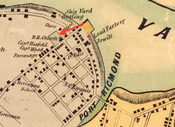
An 1874 atlas of Staten Island depicts St. Andrew’s location at the edge of the historic village of Richmond.
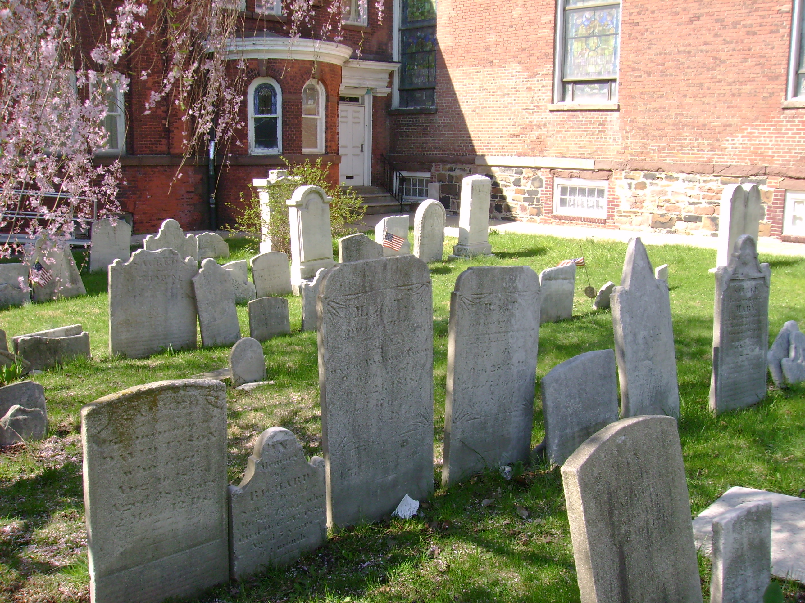
Surrounding the church building is the parish cemetery with many gravestones dating back to the Colonial period; the oldest is dated 1733. Surnames on the early gravestones include those of the area’s English settlers as well as the Dutch and French families who joined the Episcopal church. Among the notable burials is the family plot holding the remains of several relatives of Elizabeth Ann Seton, the first U.S. citizen canonized by the Catholic Church. Seton’s maternal grandfather, Rev. Richard Charlton (an early rector of St. Andrew’s) is interred here, as is her father, Dr. Richard Bayley, and her brother and sister.
A view of tombstones in St. Andrew’s Church Cemetery, April 2017 (Mary French)
Dr. Bayley was a prominent physician and his tombstone inscription is of particular historical interest. It reads: “after practicing the various branches of his Profession, with unwearied diligence and high reputation for 30 years in that City, projected the plan, and for 5 years conducted the operations of a Lazaretto on this island. Intelligent in devising and indefatigable in pursuing plans subservient to the cause of humanity, he continued to guard the public health with persevering industry, and in the midst of danger, to perform with invincible fortitude, the hazardous duties of Health Officer, until in the discharge of this important trust, he was seized with a malignant fever to which he fell a lamented victim, and thus terminated a life of great usefulness, on the 17th day of August 1801, aged 56 years.”The “Lazaretto” referred to here was the Quarantine station at Tompkinsville, which Bayley was in charge of from 1796 until he died of yellow fever contracted while caring for immigrant patients in 1801.
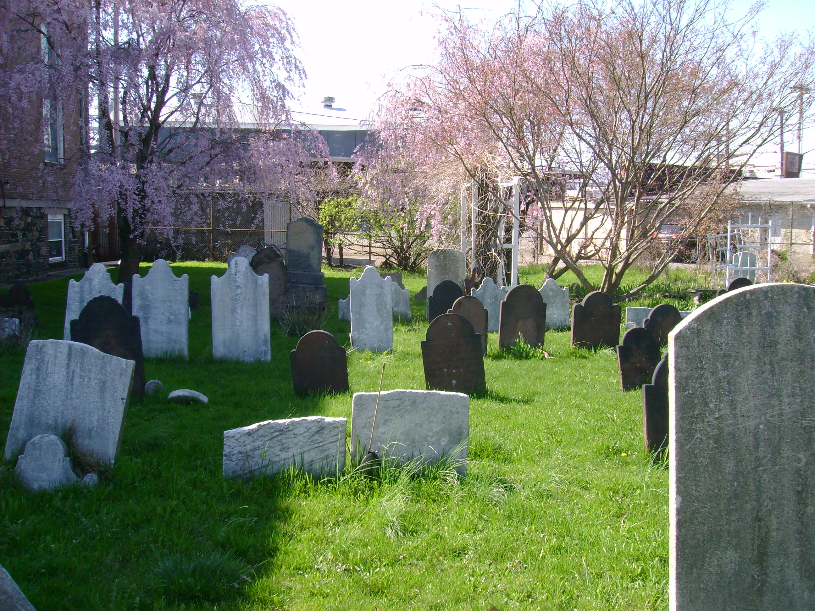
Over a thousand individuals have been laid to rest in St. Andrew’s Church Cemetery, which was enlarged in 1911 by the purchase of an old hotel property that was between the church site and Richmond Creek. This section of the cemetery opened for burials in 1924 and is still in use for new interments by the thriving parish of St. Andrew’s. Also in active use is the property’s newest addition—the Cemetery for All God’s Creatures, which is located at the back of the historic churchyard. Created by the church in 2004, the Cemetery of All God’s Creatures has 800 plots for the remains of animal companions and is the only pet cemetery within the five boroughs of New York City.
Markers in the pet cemetery at St. Andrew’s Church Cemetery, April 2017 (Mary French)A 2020 aerial view of St. Andrew’s Church and Cemetery (NYCNow&Then)
Sources: Beers 1874 Atlas of Staten Island, Sec 20; The Church of St. Andrew, Richmond, Staten Island: Its History, Vital Records, and Gravestone Inscriptions (Davis et al 1925); The Church of St. Andrew Designation Report, (Landmarks Preservation Commission 1967); Church of St. Andrew, Arthur Kill, Richmond Town, NY (NY State Cultural Information System National Register Inventory Data, 2002); Realms of History: The Cemeteries of Staten Island (Salmon 2006); “Staten Island Pet Cemetery Helps Animal Lovers Find Comfort Amid Grief,” Staten Island Advance, Nov 1, 2011; The Church of St. Andrew
In 1938, an old Dutch cemetery was demolished to make way for the expansion of the North Beach Airport—today’s LaGuardia Airport—in Queens. The small graveyard was situated on a bluff overlooking the waters of Bowery Bay, on land that had once been part of a vast estate established by Pieter Cornelisz Luyster in 1668. Pieter Luyster was a carpenter who emigrated from Holland in 1656 and was the progenitor of the Luyster family in America. After he died in 1695, the Luyster estate at Bowery Bay remained in the family for more than a century, each generation burying deceased relatives and friends in the hilltop burial ground.
By the mid-1800s, the Luyster estate had been divided into half a dozen farms that passed into other hands. In the 1870s, piano manufacturer William Steinway partnered with brewer George Ehret to acquire a large section of the old Luyster lands along the shore of Bowery Bay and in 1886 opened a pleasure garden and beach there. Reaching its peak between 1895 and 1915, Bowery Bay Beach (later called North Beach) offered swimming and boating facilities, picnic grounds, and restaurants, as well as carousels, a Ferris wheel, roller coasters, and other attractions.
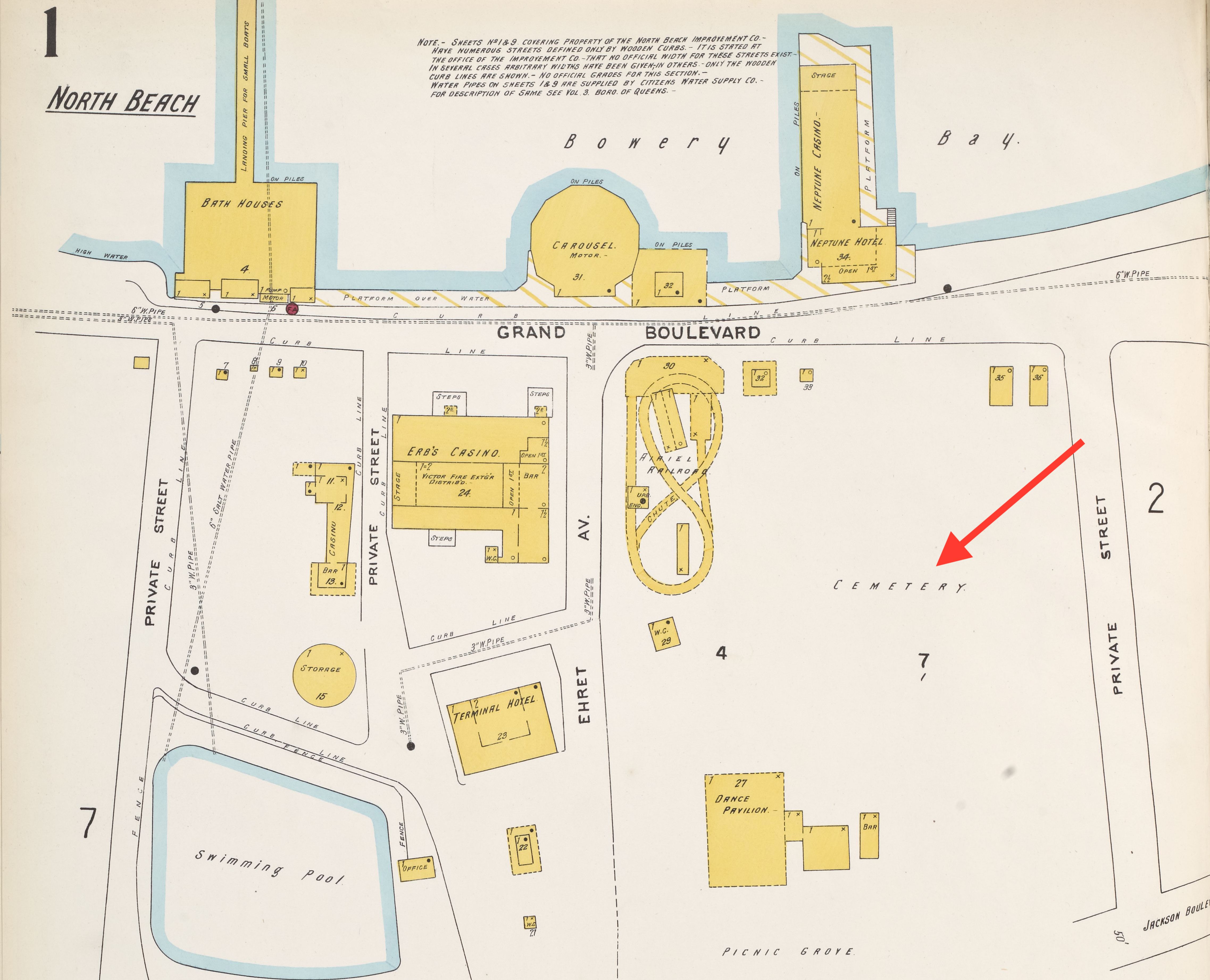
A 1903 insurance map shows the location of Luyster Cemetery within the North Beach recreational area
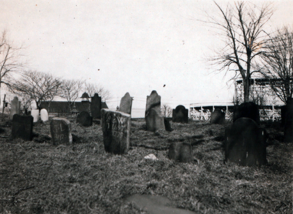
For decades, the Luyster Cemetery stood within this “Coney Island of Queens” and was frequently encountered by the recreation area’s visitors. Several early 20th-century newspaper articles describe the graveyard, which was a small square plot with apple trees at each corner offering protection to four rows of headstones. In 1903, the New York Times noted that the cemetery was between a roller coaster and a dance hall and that “picnickers camp among the stones and scatter their luncheon crumbs over the sod.”
In 1919, the Queens Topographical Bureau recorded inscriptions found on the 36 headstones still present in the Luyster Cemetery at that time. Many of the headstones were brownstone, while some were of marble and others simply rough fieldstones marked only with initials and years of birth and death. The earliest identifiable grave in the burial ground was that of Mary Luyster Rapelye (1696-1732), a granddaughter of emigrant forefather Pieter Cornelisz Luyster. The latest was that of Martin Rapelye, who died at age 81 in 1816. Most of the tombstones marked the resting places of other members of the Luyster and Rapelye families.
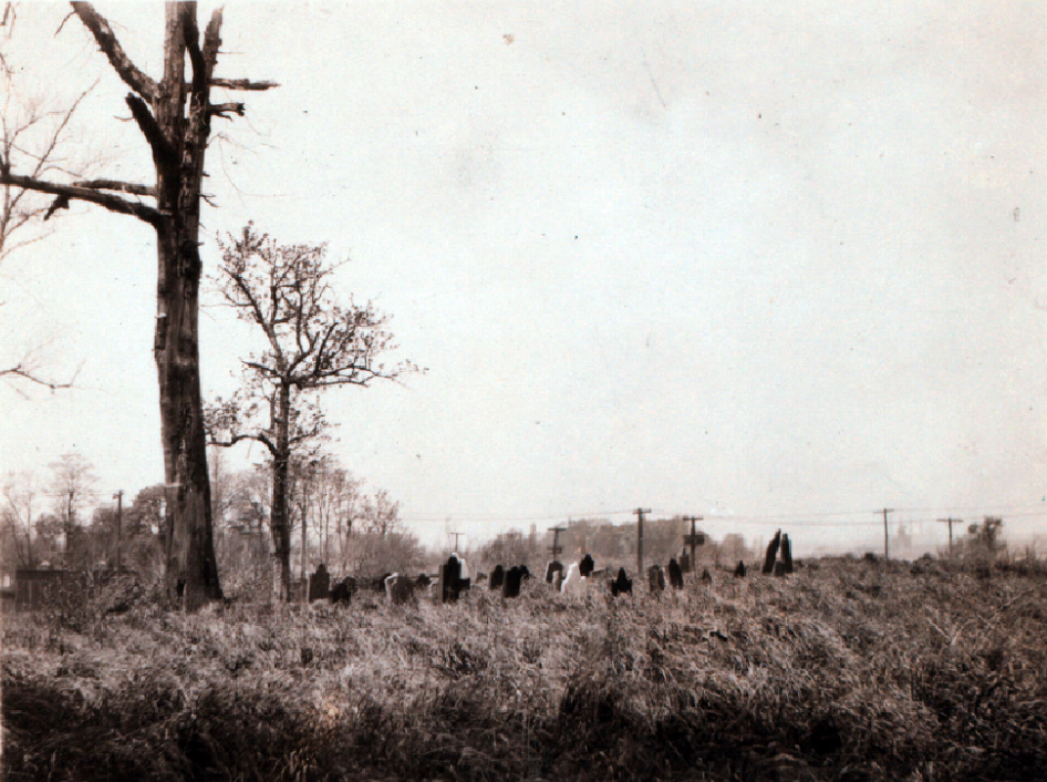
Another view of Luyster Cemetery in 1925 (NYPL)
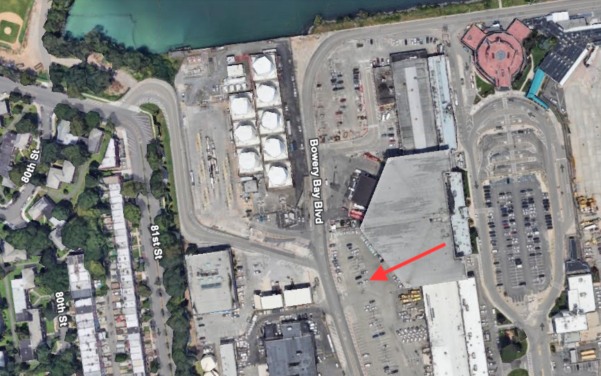
World War I and the passing of Prohibition in 1919 brought an end to the pleasure grounds at North Beach and by the 1930s the lonely little Luyster Cemetery stood among the the rotting structures that once housed its amusements. Before the area was redeveloped for the airport expansion in 1938, the Docks Commissioner arranged for the removal of the remains from the Luyster Cemetery to a plot at nearby St. Michael’s Cemetery. The last of the bodies were moved in May 1938. Today the former site of the Luyster Cemetery is near the west boundary of the LaGuardia Airport complex.
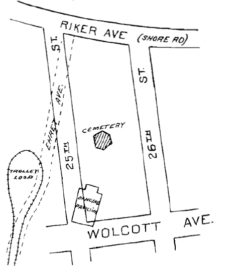
Location of Luyster Cemetery as surveyed by the Queens Topographical Bureau in 1919A 2022 satellite view of the western edge of the LaGuardia Airport complex with arrow denoting the approximate location of the former site of the Luyster Cemetery (Google Earth)
Sources: Sanborn’s 1903 Insurance Maps of the Borough of Queens, Vol 5 Pl 1; The Annals of Newtown (Riker 1852); History of Queens County (Munsell 1882); Description of Private and Family Cemeteries in the Borough of Queens (Powell & Meigs 1932); “The Luyster Burial Place,” Newtown Register, Jun 7, 1900; “Some Old Graves in North Beach,” Greenpoint Weekly Star, Aug 30, 1902; “Picnic in a Graveyard,” New York Times, Aug 3, 1903; “Graves Dug 200 Years Ago,” Brooklyn Daily Eagle, Sep 28, 1907; “North Beach Pleasure Seekers Keep Sacred Old Graveyard of Rapelye and Luyster Families,” Daily Star (Long Island City, NY), Aug 1, 1924; “Old North Beach Resort to Become Part of New Jackson Heights Airport,” Daily Star (Long Island City, NY), Feb 5, 1929; “Old North Beach Burying Ground May Vanish to Make Way for Airport,” Daily Star (Long Island City, NY), Feb 7, 1929; “Old Cemetery to Be Dug Up,” Long Island Daiy Press, Apr 30, 1938; “At City Hall,” New York Post, May 4, 1938
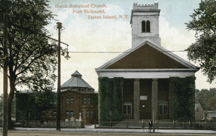
This vintage postcard shows the Port Richmond Reformed Church as it appeared in the early 1900s. Parts of the north and south cemetery sections can be seen on either side of the church (NYPL)
The Reformed Church at Port Richmond is home to the earliest congregation on Staten Island and its surrounding cemetery includes the Island’s oldest public burial ground. Situated just south of the busy intersection of Port Richmond Avenue and Richmond Terrace, this picturesque site—landmarked by the City of New York in 2010—features attractive lawns, historical buildings, artistically significant monuments, and graves of the North Shore’s early Dutch settler families.
In 1715, the Reformed Protestant Dutch Church congregation built their first house of worship at this site, next to the graveyard that had already been in use for at least a decade. Thought to have originated as a private burial ground for the Corson family in the 1690s, the graveyard is referred to in official documents as “the burying place” as early as 1705 and became the burial ground for most families on the North Shore during the 18th century. During the 19th century, the church acquired more land adjacent to the church to expand its burial grounds.
An 1853 map shows the Reformed Dutch Church and cemetery grounds at Port Richmond.
The present church at this site is the congregation’s third, built in 1844. This Greek Revival-style building was enlarged in 1898 with a Sunday school wing added on the south side of the church. The surrounding cemetery is divided into three sections to the north, south, and west of the building complex.
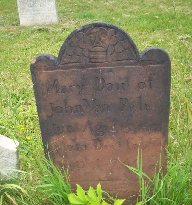
Tombstone of Mary Van Pelt (Richard Arthur Norton, June 2006)
The cemetery section to the north of the church is the oldest and incorporates the original public burial ground of the North Shore’s Dutch settlers. This section is notable for including several finely carved brown and red sandstone gravemarkers that have been ascribed to the workshops of significant New Jersey stone carvers. Of the 224 gravestones here, the oldest with a legible inscription is that of Mary Van Pelt, who died in 1746 at age 15. Her red sandstone marker is topped with a winged death’s head in a style attributed to the “Common Jersey Carver,” an anonymous artisan whose work, dating from the 1720s to 1760s, is well represented in northern New Jersey communities. Other sandstone markers in this section of the cemetery are attributed to carver Ebenezer Price, the most prominent 18th-century stonecutter in the New York-New Jersey region.
The small cemetery section to the south of the church occupies land donated by Daniel Tompkins in 1816 and includes 105 gravestones dating between 1816 and 1896. Most of the monuments here are marble and mark the graves of members of families such as the Tysons, Merseraus, Jacques, Sinclairs, Haughwouts, Crocherons, Housmans, and Posts. The 1898 Sunday school annex was built over part of this south cemetery; some graves were moved at this time but several rows of graves were left in place and remain beneath the crawl space of the the wing.
A view of the south section of the Port Reformed Church Cemetery, April 2017 (Mary French)
The third cemetery section, not visible from the street, is located behind the Sunday school wing on land purchased in 1833 (and expanded in the 1870s) by the Reformed Church to provide for future burial needs. The 363 markers here, mostly of marble or granite, date between 1834 and 1916. Notable here is the grave of congressman and state senator Judge Jacob Tyson (1773-1848) and the family plots of the Van Name, Houseman, Drake, Kholer, and Post families.
Although the Port Richmond Reformed Church is still an active congregation, no interments have been made in their cemetery grounds for over a century. Historically, the church served as a hub for the Port Richmond community that grew and was built around it. The generations of Staten Islanders that are laid to rest in the church’s grounds are part of this legacy.
A view of the north section of the Port Reformed Church Cemetery, April 2017 (Mary French)
This 2012 aerial image shows Reformed Church building and cemetery grounds on the west side of Port Richmond Avenue, just south of Richmond Terrace (NYCityMap)
Sources: Butler’s 1853 Map of Staten Island; Fairchild Cemetery Manual (1910); “History of the Reformed Church on Staten Island,”Staten Island Historian 16(1) Jan-March 1955; Realms of History: The Cemeteries of Staten Island (Salmon 2006);Reformed Church on Staten Island, Sunday School Building, and Cemetery Designation Report, (Landmarks Preservation Commission 2010); Reformed Church on Staten Island
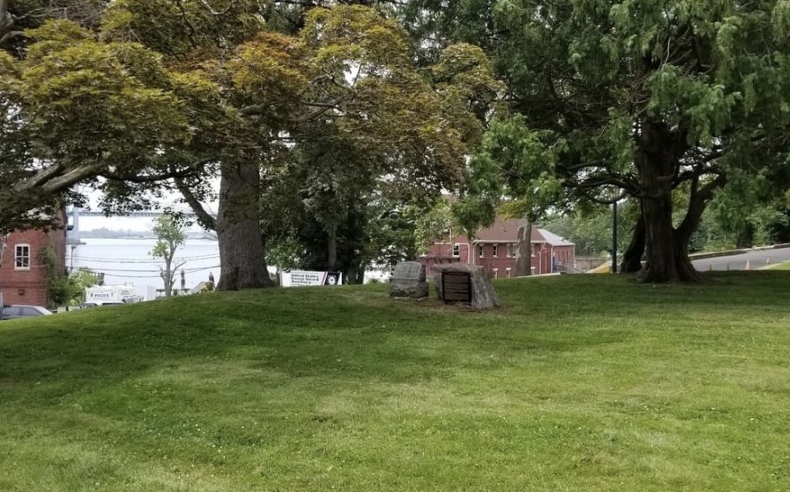
A view of the Thorne-Wilkins Cemetery in Fort Totten Park, 2019 (Tom Loggia)
Since childhood, brothers Thomas and Vincent Loggia heard family stories about ancestors buried within Fort Totten, the former U.S. Army installation on the Willets Point peninsula in northern Queens. The Willets Point name derives from Charles Willets (1781-1833), who purchased the property in 1829. Before that, the peninsula belonged to the Thorne and Wilkins families. Englishman William Thorne (1617-1664) received the land from the Dutch in 1639, and the farmland remained in his family until 1788 when Ann Thorne married William Wilkins. Thomas and Vincent Loggia are descendants of Ann Thorne and William Wilkins. For many years, evidence of their family’s ancestral burial ground was lost and officials were unaware of its presence within the fort. After 20 years of painstaking research, the Loggia brothers recently proved the existence of the burial ground and had it recognized as the Thorne-Wilkins Cemetery.
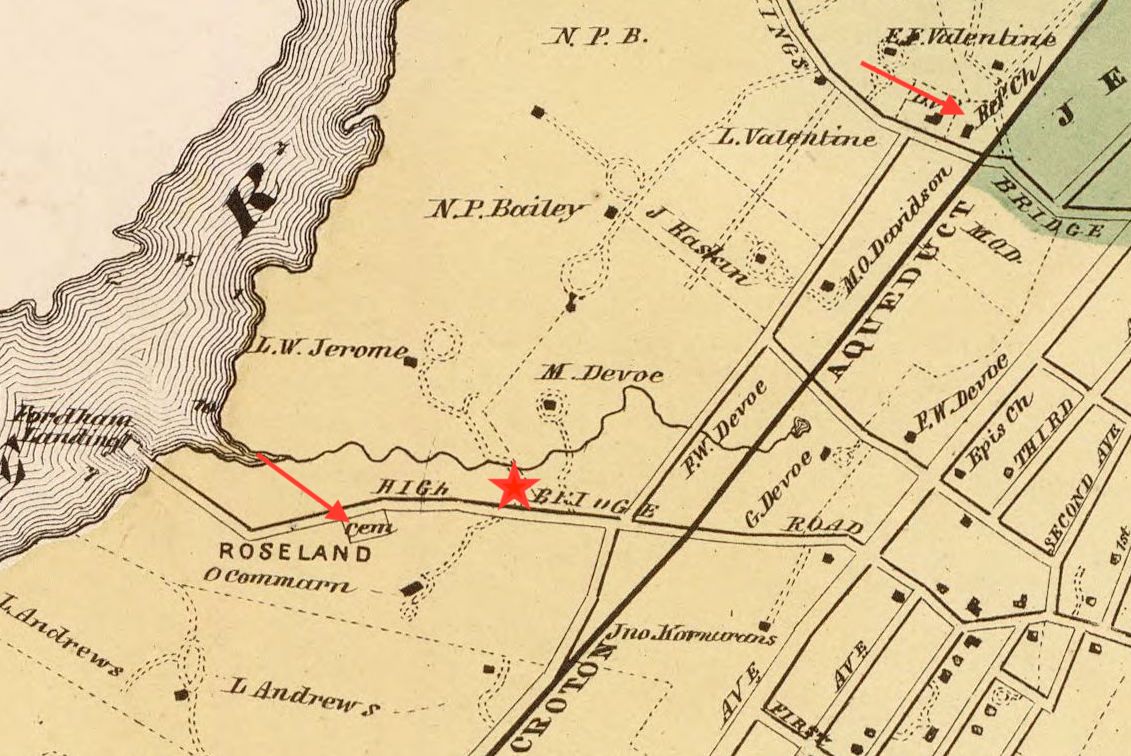
An 1860 map shows Wilkins Point (present-day Willets Point), the peninsula where Fort Totten is located today. Arrow denotes approximately location of the Thorne-Wilkins Cemetery.
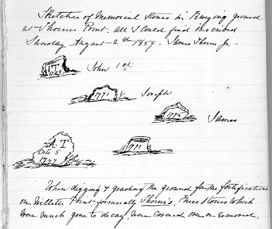
The Thorne-Wilkins Cemetery is a small plot on a knoll about 500 feet inside the entrance of Fort Totten. A clause in the 1829 deed transferring the land from Jacob Thorne Wilkins to Charles Willets reserves the burial ground for the use of the family; this exception was reiterated in later transfers of the property. Some 30 members of the Thorne-Wilkins family are thought to be buried in the plot. Family progenitor William Thorne—one of the original patentees of Flushing, Queens, and a signer of the 1657 Flushing Remonstrance—may be among those laid to rest here. Exactly who is buried here is unknown—the only documentation of the graves was made by James Thorne, Jr., who visited the burial ground in 1857 and sketched five badly weathered tombstones.Initials (“I.T.” and “A.T.”) and dates ranging from 1709 to 1775 were all that were visible on the stones.
This detail from an 1865 survey of property transferred to the U.S. government for Fort Totten shows the Thorne-Wilkins Cemetery
Between April 1857 and April 1863, the U.S. government acquired the properties to create Fort Totten, which hosted a series of military services until a large portion of the land, including the cemetery plot, was secured by New York City Parks in 2001. At that time, only one memorial stone stood on the site of the Thorne-Wilkins Cemetery—a monument to Charles Willets, the man who acquired the property from the Thorne-Wilkins family. This marker is somewhat of a historical mystery. Records show that in 1855, the Willets family removed Charles Willets’ remains and his weathered tombstone from his “Flushing farm” to a plot in Greenwood Cemetery in Brooklyn. His original burial place is not actually known; he may or may not have been interred in the Thorne-Wilkins Cemetery.
Descriptions of the Thorne-Wilkins burial ground before the 1930s do not mention Charles Willets’ tombstone at the site, suggesting this marker was placed there sometime in the early 1900s, possibly to commemorate the namesake of Willets Point rather than as an actual gravemarker. Whatever the case may be, the existence of Willets’ marker at the site in the 20th century, along with the lack of any other headstones, contributed to the loss of association of the burial ground with the Thorne-Wilkins family. By the time the property was taken over by the Parks Department, officials did not know of the Thorne-Wilkins burial ground and mistakenly believed that Charles Willets was the only civilian who had ever been interred within the fort’s grounds.
Sketches of tombstones in the Thorne-Wilkins Cemetery, 1857
In 2016, archaeologist Joan Geismar reviewed and analyzed the extensive material that Thomas and Vincent Loggia had amassed and presented it to the Parks Department to support the Loggias’ appeal to have the burial ground formally recognized as the Thorne-Wilkins Cemetery. The request was successful and in 2019, with the full support of NYC Parks and other family members, Thomas and Vincent Loggia installed a one-ton boulder at the site. One side of the massive stone holds a plaque identifying the burial ground and its history; the opposite side has an inscription honoring their seventh great-grandfather, William Thorne.
Asked in a 2012 interview why he persevered in this family quest to seek out and memorialize the lost Thorne-Wilkins burial ground, Thomas Loggia responded: “People should acknowledge things of importance. Maybe nobody will ever go visit them again. But really, that’s not the point. The point is they existed.”
A 2018 aerial view of part of Fort Totten Park; arrow indicates location of the Thorne-Wilkins Cemetery (NYCThen&Now)
Sources: Map of the City of New York and Its Environs(Walling 1860); Map of Survey of Land of Willets Point, Recently Purchased from Henry Day, Esq., by the United States (Trowbridge 1865); “Military and Civil Law Conflict,” New York Times Apr 21, 1895; “Willets Point Graveyard,” Brooklyn Daily Eagle,Dec 6, 1896; “Whitestone,” Brooklyn Times Union, Apr 26 1902; “Owned Property at Fort Totten,” Daily Star (Queens), Jan 10, 1907; “To Be Sold in Partition,” Brooklyn Daily Eagle,Apr 4, 1911; “Legendary Tunnel of 1862 Traced at Fort Totten,” Brooklyn Daily Eagle, Jun 17, 1937; “Until an Ancestral Graveyard is Found, No Time to Rest,” New York Times, Jun 1, 2012; Memo Report: Thorne/Wilkins/Willets Cemetery, Fort Totten, Queens (Geismar 2016); “Hidden in Plain Site: The Thorne-Wilkins Burying Ground,” New York Researcher, 28(4), Winter 2017; Thomas Loggia, personal communication, Jan 19, 2023
This detail from an 1868 map shows the two burial places connected with the Fordham Manor Reformed Church—the old public burial ground on Highbridge Road (today’s Fordham Road) and the Church property on the north side of Kingsbridge Road. Red star denotes approximate location of the original church site on Fordham Road, across from the old cemetery.
The modern Fordham Manor Church on Reservoir Avenue near West Kingsbridge Road is the successor to one of the earliest congregations in the Bronx. In 1696, the Dutch Reformed Church organized a society in the area then known as the Manor of Fordham. In 1706 they built their first church on the north side of Fordham Road, in present-day Devoe Park. After this building was destroyed in the Revolutionary War, a new church was built in 1801 on property about a mile north, at Kingsbridge Road. This was the first of three edifices to stand on that site; the second church was built in 1849, and the present building was erected in 1940. During the 18th and 19th centuries, the Dutch Reformed Church of Fordham Manor used two local cemeteries to bury their dead—a public burial ground near their original house of worship on Fordham Road and a small cemetery next to their church on Kingsbridge Road.
Public Burial Ground, Fordham Road
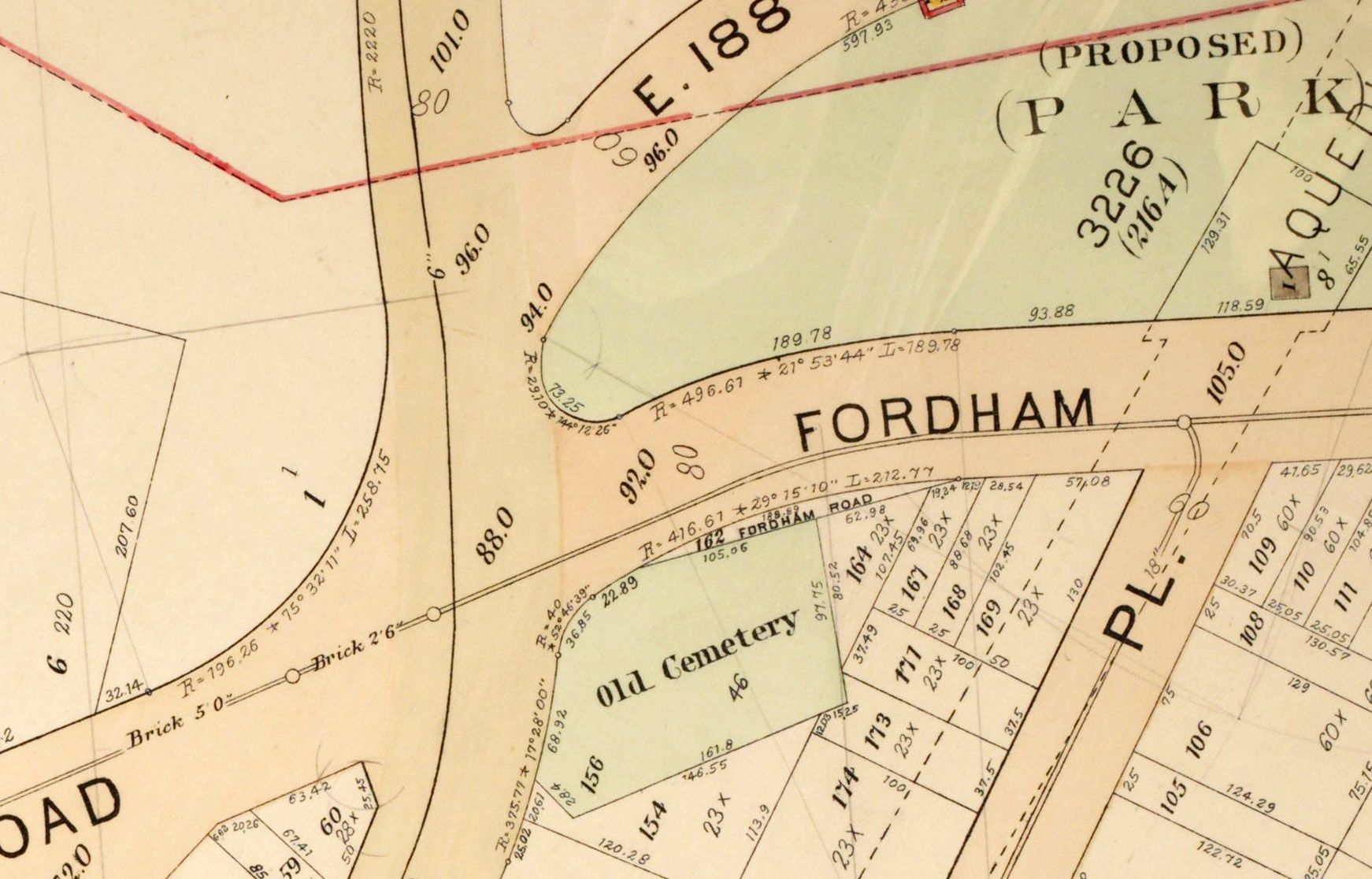
Until 1909, an “ancient Dutch burying ground” stood at the southeast corner of today’s Sedgwick Avenue and West Fordham Road, where an apartment building is located today. Exactly when this cemetery was established is not known; it may have been used as far back as the 1600s when Dutch families began to settle in the area. Deeds dated before the Revolution refer to the one-and-a-half-acre cemetery as a public burial ground and it was known to have been used as a free burial ground by local authorities into the 19th century. During its early history, this public cemetery was linked with the Dutch Reformed church that originally stood 200 yards from it, on the opposite side of Fordham Road. After the congregation moved up to Kingsbridge Road in the early 1800s, their ties with the village burial ground were eventually broken. By the late 1800s, the public burial ground at the intersection of Sedgwick Ave and Fordham Road was known to many locals as the “Berrian Cemetery,” for one of the families who owned land surrounding the cemetery and who had interred a number of their kinfolk in the graveyard.
A 1901 map depicts the old burial ground at the intersection of Fordham Road and Sedgwick Avenue
One 19th-century historian estimated that perhaps 1,000 people were interred in the cemetery on Fordham Road and Sedgwick Avenue. Genealogists who visited the site in the 1870s and 1880s recorded tombstones with family names including Berrian, Valentine, Cromwell, Laurence, DeVoe, Hart, and Rowland. The earliest date found was 1810 and the latest was 1863. Less than two dozen graves had headstones with identifiable inscriptions; many more graves were designated by rough, flat stones with no markings. Guarding the graveyard was a magnificent willow tree, over 20 feet in circumference, which stood at the edge of the property.
1906 view of the burial ground at Fordham Road and Sedgwick Avenue, showing toppled tombstones and the huge willow tree that sheltered the site (Comfort)
By the turn of the century, the cemetery was neglected and partially destroyed by street construction. The western portion of the graveyard was taken by the city in 1874 for the opening of Sedgwick Avenue and a section on the north part of the property was cut off in the 1890s when Fordham Road was widened. Many families had arranged to have their family members’ remains moved to other cemeteries, the numerous disinterments causing further disturbance to the burial ground. Newspaper articles describe it as a place of “sad havoc,” a mass of broken tombstones, brush, and rubbish. Ownership and responsibility of the property was a tangle of uncertainty until the early 1900s when a court-appointed referee ruled that the Camman family, who had acquired the Berrian farm in 1852, could sell the cemetery property once they arranged for removal of the remains. Workmen excavated the cemetery in the winter of 1908-1909 and packed up any bones they found. The exhumed remains were reburied in a plot at Ferncliff Cemetery in Westchester. In 1927 a six-floor apartment building, still present, was erected on the site of the old Dutch burial ground of Fordham Manor.
Fordham Manor Church Cemetery, Kingsbridge Road
In 1801, Dennis Valentine, Sr., donated land for construction of a new Dutch Reformed Church at the Manor of Fordham. The plot, 90 feet deep and 74 feet across, was located near the northwest corner of what is now Kingsbridge Road and Reservoir Avenue. In 1836, the church appointed a committee to look for land for a burial place. The congregation apparently continued to use the old burial ground at Fordham Road and Sedgwick Avenue for some time after they moved to their new location, the donation having included only enough property to accommodate the building. In 1849, Dennis Valentine, Jr., donated additional lands adjacent to the 1801 church property to provide sufficient ground for erection of a new house of worship and for a burial ground. The new building was erected on the property immediately adjoining the 1801 structure and facing Kingsbridge Road. Land to the rear of the church was used for a cemetery. The last known interment here was in 1884.
1901 map depicting the Fordham Manor Reformed Church building on Kingsbridge Road, with the cemetery behind it
Several families had vaults in the church cemetery, including members of the Valentine, Briggs, and Archer clans. After Woodlawn Cemetery was established in 1863, each of these families acquired plots there and had the remains of their family members relocated to Woodlawn from the church cemetery. Notable among the removals from the Valentine family vaults were the remains of Virginia Clemm, wife of Edgar Allan Poe. In 1847, Virginia Clemm died while she and her husband were living in a rented cottage (preserved as Poe Cottage) on the Valentine farm. She was laid to rest in the private vault of Dennis Valentine, Sr., which he built in the 1830s on his land adjacent to the 1801 Fordham Manor Church building. Although officially separate from the church burial ground, it was generally considered part of the cemetery. When the Valentine family removed the remains from their vaults in the late 1870s, Virginia Clemm’s remains were taken to Baltimore for reburial alongside her husband, who died in 1849.
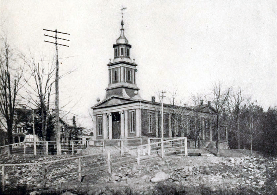
A 1912 view of the Fordham Manor Reformed Church building on Kingsbridge Road, erected in 1849. The church cemetery, located to the rear of the building, is not visible (Jenkins)
In August of 1912, the journal Genealogy published inscriptions from the Fordham Manor Reformed Church Cemetery. The burial ground behind the church was described as “a neglected corner plot, overgrown with weeds, where a few tombstones, some badly broken, still remain.”Inscriptions from the 20 tombstones found at the site included members of the Poole, Webb, Archer, Horton, Corsa, and Webb families. The earliest dated to 1843 and the latest to 1870.
In the early 1920s, the Fordham Manor Reformed Church authorities made plans to purchase a nearby house and have it moved to the church property for use as a parsonage. Before this could be done, it was necessary to clear the cemetery of bodies. After receiving the necessary permissions, in 1925 the remains of 32 people were exhumed from the cemetery behind the church and reburied in a plot at Kensico Cemetery in Westchester. In 1940, the Fordham Manor Reformed Church demolished their 1849 church building and the parsonage, sold the southern portion of their property along Kingsbridge Road, and built a new edifice on the northern part of their land, where their cemetery once stood. The 1940 building, which faces Reservoir Road, is the home of the present Fordham Manor Church, now a nondenominational congregation.
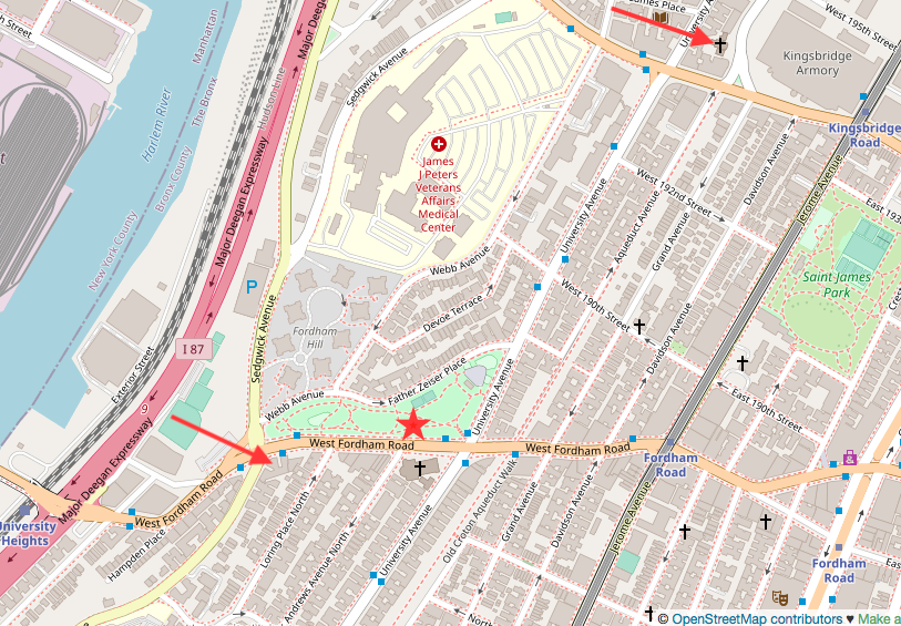
A modern map with arrows denoting the former site of the cemetery at Fordham Rd and Sedgwick Ave and the present Fordham Manor Church at Reservoir Ave near Kingsbridge Rd, on the site of the former church cemetery. Red star denotes the approximate location of the original church site on Fordham Road (OpenStreetMap)
2018 aerial view of the apartment building on the former cemetery site at Fordham Rd and Sedgwick Ave (NYCThen&Now)
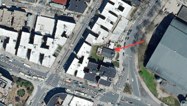
2018 aerial view of the present Fordham Manor Church property on Reservoir Avenue, formerly the site of the church cemetery (NYCThen&Now)
Sources: Beers’ 1868 Atlas of New York and Vicinity, Pl 8; Hyde’s 1901 Atlas of the Borough of the Bronx, Pl 25 & 32; Genealogy of the DeVeaux Family (De Voe 1885); History of Bronx Borough (Comfort 1906); The Story of The Bronx (Jenkins 1912); History of Fordham Manor Reformed Church, 1696-1946 (Attwood 1946); “Old Burial Grounds in Westchester Co, NY,”NYG&B Record 20 (2) 1889; “Notes & Queries,” NYG&B Record 22 (4), 1891; “Neglected Graves at Fordham Heights,” Evening Telegram, May 7, 1892; “A Neglected Cemetery,” New York Times, Dec 22, 1901; “Facts About the Berrian Cemetery,” New York Times, Dec 30, 1901; “Old Historic Cemeteries,” Daily Argus (Mount Vernon, NY) Jan 9, 1905; “Historical Cemetery Despoiled,” Magazine of American History, 36 (11), Nov 1908; “Poole Family Burials,” Genealogy 2(6), Aug 10, 1912; “From a New York Cemetery,” Genealogy 2(7), Aug 17, 1912; “Church in Bronx to Have New Home,” New York Times, Feb 17, 1940; Cemeteries of the Bronx (Raftery 2016)