Tag Archives: church cemeteries

41st Street Reformed Presbyterian Church Cemetery

This detail from a modern map overlaid with an 1852 map of Manhattan shows the 41st Street Reformed Presbyterian Cemetery that existed in the mid-19th century and the Port Authority Bus Terminal ramps that cover the site today.

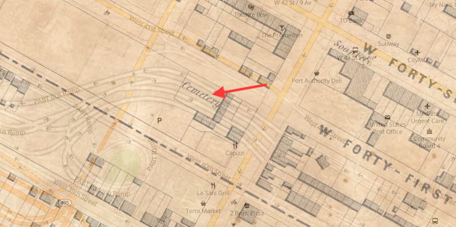
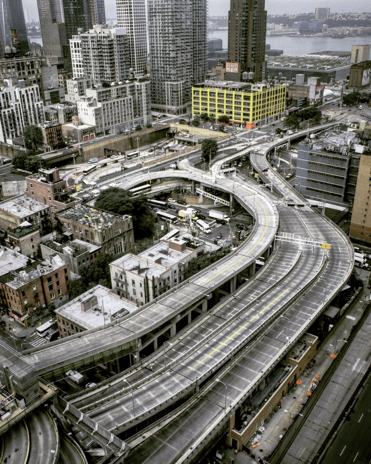
The Port Authority Bus Terminal in Manhattan is the busiest bus station in the world, with a quarter of a million commuters and intercity passengers arriving or departing via 8,000 buses on a typical weekday. Located on Eighth Avenue between 40th and 42nd streets in Midtown, the terminal has a unique ramp system that provides a direct connection to the Lincoln Tunnel. These ramps are built over the site where the 41st Street Reformed Presbyterian Church Cemetery once existed.

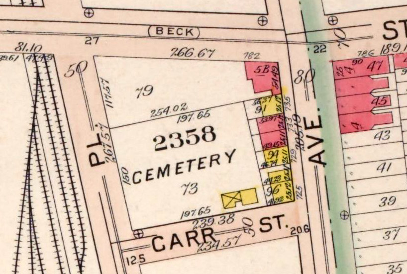
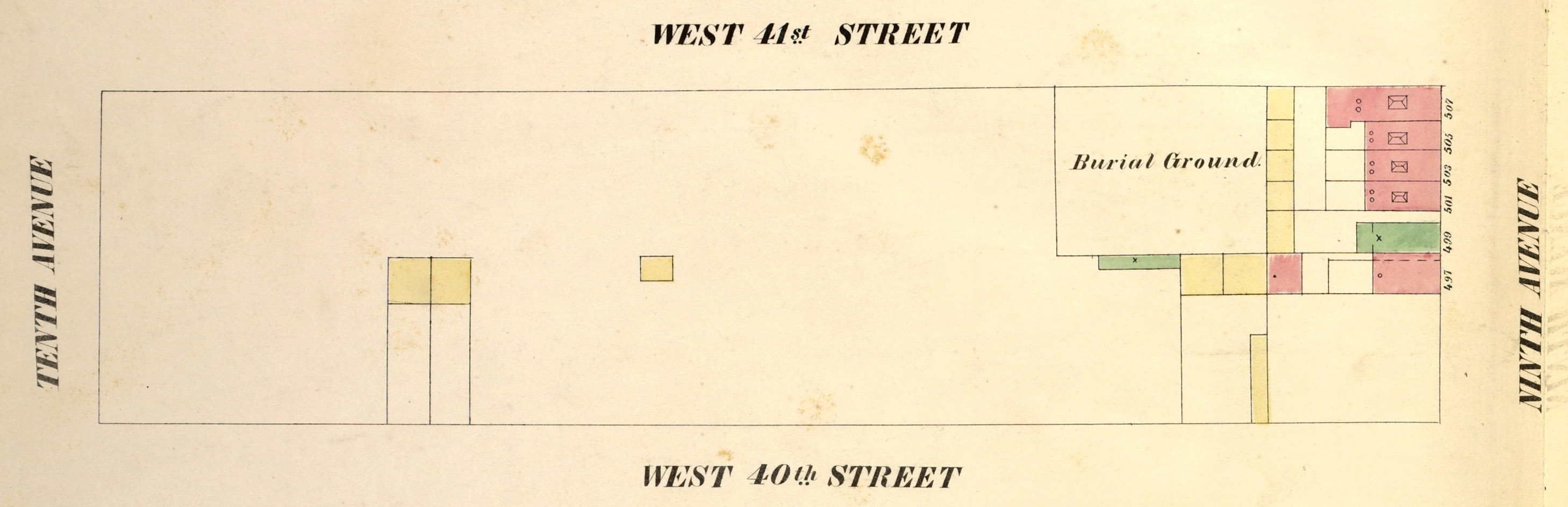
The Reformed Presbyterian Church Cemetery, approximately 125 feet wide and 100 feet deep, was located 100 feet west of Ninth Avenue on the south side of West 41st Street. The property was acquired for use as a burial ground in 1832, by three elders of the Reformed Presbyterian Church. The Reformed Presbyterian Church is a small denomination that originated in Scotland in 1690 when its members refused to become part of the national Church of Scotland.

The Reformed Presbyterian Church Cemetery in 1854.

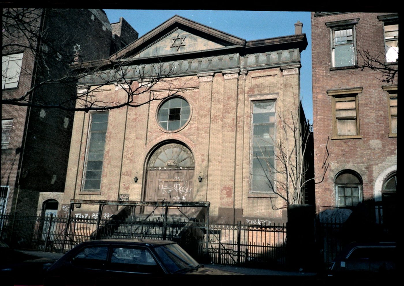
The first Reformed Presbyterian congregation in New York City was organized in 1797 and had a church on Chambers Street in downtown Manhattan; in 1830 members living further uptown incorporated as the Second Reformed Presbyterian congregation and acquired a church at 166 Waverly Street in Greenwich Village; in 1848, part of this congregation split to form the Third Reformed Presbyterian congregation. After the 1848 split, the Third congregation remained at the Waverly Street location while the Second congregation erected a church on 11th Street near Sixth Avenue. Records show the 41st Street cemetery was used by both the Second and Third Reformed Presbyterian congregations, which collectively had about 500 members.

An 1856 notice of the removal of the 41st Street Reformed Presbyterian Cemetery

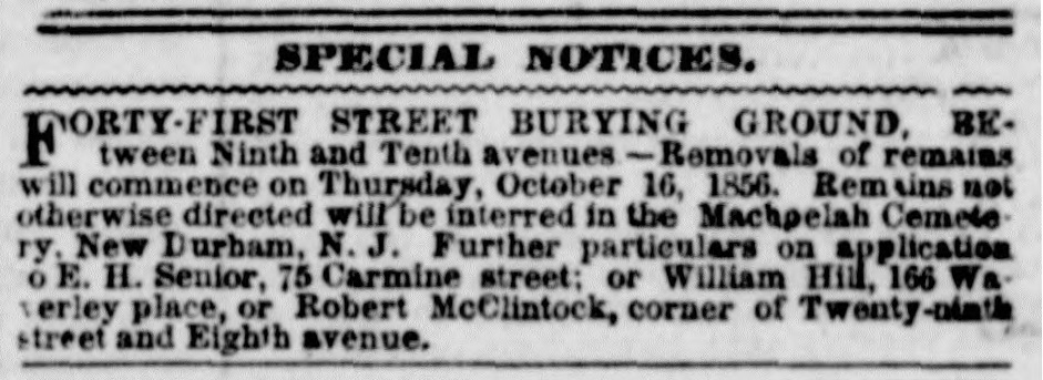
No records have been found to tell us how many people were interred in the Reformed Presbyterian Cemetery on 41st Street, or the names of those who were laid to rest there during the two-and-a-half decades it was utilized for burials. In October of 1856, church trustees removed the remains of those interred in the 41st Street burial ground to Machpelah Cemetery in what is now North Bergen, New Jersey.

In 1858, the Trustees of the Second and Third Reformed Presbyterian congregations sold the cemetery property and it was redeveloped. In 1890, the location of the former cemetery was occupied by a rag warehouse and other structures. Construction of the Port Authority Bus Terminal began in the late 1940s. Today, the piers supporting the ramp system, and several buildings beneath the ramps, stand on the former site of the 41st Street Reformed Presbyterian Cemetery.

A 2021 view of the ramps and other structures that cover the former site of the 41st Street Reformed Presbyterian Cemetery (Michael Young)

Sources: Dripps’ 1852 Map of the City of New-York extending northward to Fiftieth St; Perris’ 1854 Maps of the City of New York, Vol 7 Pl 97; “Special Notices,” New York Herald, Oct 10, 1856; “City Items—A Burying Ground Closed,” New York Daily Tribune, Oct 16, 1856; “City Intelligence—Removing the Dead,” New York Herald, Oct 17, 1856; History of the Reformed Presbyterian Church in America (Glasgow 1888); Archaeological Documentary Study, No. 7 Line Extension/Hudson Yards Rezoning (Parsons Brinckerhoff et al 2004);  Prepare for Death and Follow Me:”An Archaeological Survey of the Historic Period Cemeteries of New York City (Meade 2020); “A New Port Authority Bus Terminal in New York,” TR News 31 Nov-Dec 2017; “Port Authority Bus Terminal to Receive Multi-Billion-Dollar Overhaul in Midtown Manhattan,” New York YIMBY, Feb 1, 2021

Port Richmond Reformed Dutch Church Cemetery

This vintage postcard shows the Port Richmond Reformed Church as it appeared in the early 1900s. Parts of the north and south cemetery sections can be seen on either side of the church (NYPL)

The Reformed Church at Port Richmond is home to the earliest congregation on Staten Island and its surrounding cemetery includes the Island’s oldest public burial ground. Situated just south of the busy intersection of Port Richmond Avenue and Richmond Terrace, this picturesque site—landmarked by the City of New York in 2010—features attractive lawns, historical buildings, artistically significant monuments, and graves of the North Shore’s early Dutch settler families.

In 1715, the Reformed Protestant Dutch Church congregation built their first house of worship at this site, next to the graveyard that had already been in use for at least a decade. Thought to have originated as a private burial ground for the Corson family in the 1690s, the graveyard is referred to in official documents as “the burying place” as early as 1705 and became the burial ground for most families on the North Shore during the 18th century. During the 19th century, the church acquired more land adjacent to the church to expand its burial grounds.

An 1853 map shows the Reformed Dutch Church and cemetery grounds at Port Richmond.

The present church at this site is the congregation’s third, built in 1844. This Greek Revival-style building was enlarged in 1898 with a Sunday school wing added on the south side of the church. The surrounding cemetery is divided into three sections to the north, south, and west of the building complex.

Tombstone of Mary Van Pelt (Richard Arthur Norton, June 2006)

The cemetery section to the north of the church is the oldest and incorporates the original public burial ground of the North Shore’s Dutch settlers. This section is notable for including several finely carved brown and red sandstone gravemarkers that have been ascribed to the workshops of significant New Jersey stone carvers. Of the 224 gravestones here, the oldest with a legible inscription is that of Mary Van Pelt, who died in 1746 at age 15. Her red sandstone marker is topped with a winged death’s head in a style attributed to the “Common Jersey Carver,” an anonymous artisan whose work, dating from the 1720s to 1760s, is well represented in northern New Jersey communities. Other sandstone markers in this section of the cemetery are attributed to carver Ebenezer Price, the most prominent 18th-century stonecutter in the New York-New Jersey region.

The small cemetery section to the south of the church occupies land donated by Daniel Tompkins in 1816 and includes 105 gravestones dating between 1816 and 1896. Most of the monuments here are marble and mark the graves of members of families such as the Tysons, Merseraus, Jacques, Sinclairs, Haughwouts, Crocherons, Housmans, and Posts. The 1898 Sunday school annex was built over part of this south cemetery; some graves were moved at this time but several rows of graves were left in place and remain beneath the crawl space of the the wing.

A view of the south section of the Port Reformed Church Cemetery, April 2017 (Mary French)

The third cemetery section, not visible from the street, is located behind the Sunday school wing on land purchased in 1833 (and expanded in the 1870s) by the Reformed Church to provide for future burial needs. The 363 markers here, mostly of marble or granite, date between 1834 and 1916. Notable here is the grave of congressman and state senator Judge Jacob Tyson (1773-1848) and the family plots of the Van Name, Houseman, Drake, Kholer, and Post families.

Although the Port Richmond Reformed Church is still an active congregation, no interments have been made in their cemetery grounds for over a century. Historically, the church served as a hub for the Port Richmond community that grew and was built around it. The generations of Staten Islanders that are laid to rest in the church’s grounds are part of this legacy.

A view of the north section of the Port Reformed Church Cemetery, April 2017 (Mary French)
This 2012 aerial image shows Reformed Church building and cemetery grounds on the west side of Port Richmond Avenue, just south of Richmond Terrace (NYCityMap)

Sources: Butler’s 1853 Map of Staten Island; Fairchild Cemetery Manual (1910); “History of the Reformed Church on Staten Island,” Staten Island Historian 16(1) Jan-March 1955; Realms of History: The Cemeteries of Staten Island (Salmon 2006); Reformed Church on Staten Island, Sunday School Building, and Cemetery Designation Report, (Landmarks Preservation Commission 2010); Reformed Church on Staten Island

First Reformed Dutch Church of Brooklyn Cemetery

An 1834 map of Brooklyn depicts the First Reformed Dutch Church of Brooklyn Cemetery on Fulton Street between Smith and Hoyt Streets; the Church can be seen west of the cemetery, on Joralemon Street, where there congregation relocated in 1807

One of New York’s earliest Dutch burial grounds was located where the iconic Abraham & Straus building stands today in downtown Brooklyn. Situated on the south side of Fulton Street near Hoyt Street, the department store site was previously the graveyard of the First Reformed Dutch Church of Brooklyn, established by order of Governor Peter Stuyvesant in 1654. The half-acre cemetery was in use by 1656 and in 1666 the Reformed Dutch Church erected their first house of worship east of the burial ground, in the middle of the colonial highway that evolved into Fulton Street. In 1766, a new church was erected on the same site; this stood until 1807 when the congregation relocated to nearby Joralemon Street. In 1886 the congregation moved again, to the Park Slope location where they continue to worship today.

After the First Reformed Dutch Church of Brooklyn moved to Joralemon Street, they tore down the Fulton Street church but retained the old burial ground. They continued interments there until the 1840s when an ordinance prohibited further burials within Brooklyn city limits. In the winter of 1862-1863, politician and historian Henry Cruse Murphy twice visited the disused Dutch burial ground on Fulton Street and recorded the inscriptions he found on nearly 100 tombstones at the site. Dates of death on the gravemarkers ranged from the 1740s to the 1840s and names included those of some of Brooklyn’s original Dutch settlers, such as Boerum, Remsen, and Barkeloo.

Ancient tombstones mark graves transferred from the First Reformed Dutch Church Cemetery on Fulton Street to the Cedar Dell section at Greenwood (Mary French, May 2016)

In 1865, the First Reformed Church began making arrangements to remove their Fulton Street cemetery so that the property could be sold. They acquired a large plot of ground at Greenwood Cemetery and in 1866 received permission from the State Legislature to disinter the bodies and relocate them to Greenwood, a process that was completed in 1868. Developer Andrew S. Wheeler subsequently acquired the former burial ground on Fulton Street and in 1873 erected a five-story cast-iron-fronted luxury commercial building on the site. In the 1880s, retailers Wechsler & Abraham purchased the building, rebuilt the interior, and added an extension to create a lavish department store; the company became Abraham & Straus in 1893. Now Macy’s, this building has long been the heart of downtown Brooklyn’s Fulton Mall shopping corridor.

Though gone from its original location in downtown Brooklyn, the essence of the First Reformed Dutch Church of Brooklyn burial ground can be found in Greenwood Cemetery’s Cedar Dell section, where the circular layout of tombstones relocated from Fulton Street makes it one of the cemetery’s signature areas. The distinctive brownstone monuments are some of the oldest at Greenwood and were recently restored as part of a major renovation of the Cedar Dell section. One by one, the old tombstones were unearthed, cleaned, and reset, revealing inscriptions hidden for decades and uncovering reminders of Brooklyn’s forgotten past.

The Cedar Dell section at Greenwood Cemetery, May 2016 (Mary French)
Before and after photos of the gravestone of Sarah Bouton (d. 1823) show the transformation achieved by Greenwood Cemetery’s restoration team in repairing and resetting the First Reformed Dutch Church Cemetery monuments at Greenwood Cemetery (Neela Wickremesinghe @brooklyn_conservator)
The First Reformed Dutch Church Cemetery in 1855
Detail from an 1886 map (left) showing the Wechsler & Abraham department store (later Abraham & Straus) that was built on the First Reformed Dutch Church Cemetery site; a 2022 Google Earth view shows the original store and its expansions, still at at the site today.

Sources: Martin’s 1834 Map of Brooklyn, Kings County, Long Island; Perris’ 1855 Maps of the City of Brooklyn, Pl 28; Robinson’s 1886 Atlas of the city of Brooklyn Pl 2; History of the First Reformed Protestant Dutch Church of Breuckelen, now known as The First Reformed Church of Brooklyn, 1654 to 1896; The Ferry Road on Long Island (Armbruster 1919); “Memoranda Taken from the Tombstones in the Old Dutch Burying Ground in Fulton St…” Long Island Historical Society Quarterly July 1939; “Our Albany Correpondence,” Brooklyn Daily Eagle, Mar 28, 1866; “An Old Landmark Gone,” Brooklyn Union, May 14, 1868; “Old Dutch Burying Ground,” Brooklyn Daily Eagle, Nov 29, 1872;  “The Dead…Brooklyn Graves That Have Been Opened,” Brooklyn Daily Eagle, Oct 2 1875; “The Old Dutch Grave Yard,” Brooklyn Daily Eagle, Mar 28, 1881; “Old Burial Ground,” Brooklyn Daily Eagle,” Aug 28, 1886;  “Restoring Brooklyn’s Queen of Department Stores,” New York Times, Nov 22, 2019;  Ooooh, look at that curve!, The Green-Wood Cemetery, Facebook, Sep 2, 2022; [Sarah Bouton tombstone], @brooklyn_conservator, Instagram, Oct 25, 2022

Melrose Cemetery

Melrose Catholic Cemetery in 1867

Melrose Cemetery was a 19th-century German Catholic burial ground that was situated on land that is now within the courtyard of the Bronxchester public housing development in the Melrose section of the South Bronx. In November of 1853, Rev. John Hughes, Archbishop of the Archdiocese of New York, purchased a parcel of land on the north side of Carr Street, which was just south of present-day East 156th Street between St. Ann’s Avenue and Hegney Place.  Archbishop Hughes acquired the 200 ft x 150 ft  property to serve the burial needs of the new German Catholic Church of the Immaculate Conception, which opened on East 150th Street at Melrose Avenue in May of 1853.

While Melrose Cemetery was primarily a burial ground for the local Immaculate Conception parish, records show a number of German Catholic residents of Manhattan were also laid to rest here during the 25 years the cemetery was in operation. The Archdiocese required Manhattan’s parishes to bury their dead at Calvary Cemetery in Queens during this time; however, many German Catholics preferred interment among their Teutonic brothers and sisters rather than at the Irish-dominated Calvary. Archbishop Hughes quashed several attempts by the city’s German Catholic parishes to establish their own burial grounds in Manhattan; it appears Melrose Cemetery served as an Archdiocese-sanctioned alternative burial place for the city’s German Catholics until the cemetery closed in the 1870s.

Obituary of Catharina Ehatt, a member of the German Catholic parish of St. Joseph’s in Harlem, who was interred in Melrose Cemetery in 1870

After Melrose Cemetery closed to burials in the 1870s, the property was abandoned and neglected. Friends and relatives transferred the remains of most of those buried here to other cemeteries, but many graves of the unclaimed were still present and in a sad state of misuse when an Evening Post reporter visited the site in 1899. Referring to the cemetery as “St. Mary’s,” the newspaper reports that the German Catholic graveyard at Melrose had become a “pasturage for eight or ten cows, and a barnyard in which a hundred or more hens take their recreation, and dismantled wagons and trucks are heaped up in the corners.” Graves surrounded by little iron fences were still visible, as were several headstones, including those of Michael Bundscheih (d.1871), Katherina Weiners (d.1861), and Joseph Bramen (d.1865).

The cemetery continued in its abandoned state until the property was condemned by the city as part of the Bronxchester Urban Renewal Project in 1974. It is not known if any remaining graves were transferred from the site before the property was redeveloped into a courtyard and recreational area for the Bronxchester Houses.

This detail from a 1904 map depicts the location of Melrose Cemetery on the north side of Carr St, south of E 156th St between German Pl (today’s Hegney Pl) and St. Ann’s Ave
A 2018 aerial view shows the Bronxchester public housing development; arrow indicates approximate location of the former location of Melrose Cemetery (NYCThen&Now)

Sources: Beer’s 1867 Plans of Westchester, West Farms, Morrisania, Westchester Co. and Part of New York County; Bromley’s 1904 Atlas and owner’s names, borough of the Bronx Pl 7; Westchester County Conveyances, Vol 256 p219-221, “United States, New York Land Records, 1630-1975,” FamilySearch; Bodies in Transit Registers IX & X, Municipal Archives, City of New York; “Died,” New York Herald, Aug 4 1867; “Died,” New York Herald , Nov 27 1870; “Neglected Graves in Melrose,” Evening Post, Dec 2 1899; “The Catholic Cemeteries of New York,Historical Records and Studies 1 (1900); “Detailed List of Exempt Properties of the City of New York, 1919” The City Record, May 23 1919 Supplement; Cemeteries of the Bronx (Raftery 2016)

Attorney Street Methodist Protestant Church Burial Vaults

Newspaper headline, Apr 4, 1880

Early on an April morning in 1880, inhabitants of the crowded tenement buildings near the corner of Attorney and Delancey streets on Manhattan’s Lower East Side were startled by a crashing sound and  trembling of the ground that was first thought to be an earthquake. Upon the commotion, a Mr. Baker, who lived in an apartment next to the Wesley Methodist Chapel on Attorney Street, looked out of his window and saw what used to be a churchyard behind the chapel had become a hole in the ground. The church sexton came running from his home across the street, declaring that he knew as soon as he heard the great noise that the old burial vaults in the churchyard had fallen in.

This snippet from an 1852 map shows the Attorney Street Methodist Protestant Church and the rear yard where the burial vaults were located

The church was built in 1831 by the society of the First Methodist Protestant Church, one of the earliest Methodist Protestant congregations in the country. Behind their brick church building, which faced Attorney Street, was a small square yard where they constructed two underground burial vaults for the reception of bodies; these were reportedly quickly filled during the local cholera epidemics of the 1830s and 1840s. The Attorney Street Methodist Protestant Church acquired land in Brooklyn for future burials—first in Williamsburg and later in Bushwick—and the burial vaults behind their church probably ceased to be used in the 1850s. In 1873, the Attorney Street congregation itself relocated to Brooklyn, becoming the Fourth Street Methodist Protestant congregation in Williamsburg. They sold their property on Attorney Street to the Methodist Church Extension Society, which reopened it as a mission chapel.

Very few people in the neighborhood knew that there were vaults behind the church at the time they collapsed in 1880. A former sexton, speaking to newspaper reporters, claimed nearly 5,000 bodies were interred in the vaults. When the roof collapsed, the vaults became a jagged pit 12 feet deep, 25 long, and 15 feet wide. At the sides of the fallen plot of earth, beneath the arched side walls, scores of coffins could be seen, of every shape and size, broken and in disorder. Parts of skeletons were also visible among the debris.

Rather than exhuming the remains from the vaults and relocating them to another cemetery, the church trustees hired workmen to repair the roof by building two brick walls to support the arch. Remains exposed during the collapse were covered with earth excavated for the foundations of these walls.

The synagogue at 87 Attorney Street, originally the Attorney Street Methodist Protestant Church, just before it was demolished in 1989 (VillagePreservation)

In the late 1890s, the old Methodist church building on Attorney Street became home to a Jewish congregation and continued to be used as a synagogue until the building was demolished in 1989. In 2000, an apartment building was built on the church site but the rear yard was left as open space.

Like their 1880s counterparts, it’s likely no one in the neighborhood today is aware that burial vaults—and the remains of several thousand 19th-century Lower East Siders—may still be present under the small rear yard at 87 Attorney Street.

An 1879 map shows the Attorney Street Methodist Church property and surrounding neighborhood about the time the burial vaults collapsed
A 2022 aerial view shows the apartment building on the site of the Attorney Street Methodist Protestant Church, and the rear yard where the underground burial vaults may still be present (GoogleEarth)

Sources: Dripps’ 1852 Map of the City of New-York extending northward to Fiftieth St; Bromley’s 1879 Atlas of the Entire City of New York, Pl 6; New York County Conveyances, Vol 265, p615-617, Vol 282 p534-536, “United States, New York Land Records, 1630-1975,” FamilySearch; Cyclopaedia of Methodism (Simpson 1880); Annals of New York Methodism (Seaman 1892); From Abyssianian to Zion: A Guide to Manhattan’s Houses of Worship (Dunlap 2004); “The Corner Stone of the Associated Methodist Church…” Commercial Advertiser, Oct 27 1830; “Notice,” New York Evangelist, Apr 2 1831; Doggett’s New-York City Directory for 1845 & 1846; “Burial Vaults Caving In,” The Sun, Apr 4 1880; “An Old Burial Vault Opened,” New York Tribune, Apr 4 1880; “An Old Burial-Vault Caves In,” New York Times, Apr 4, 1880; “City and Suburban News,” New York Times, Apr 6 1880; “Undermining the Church,” The Sun, Apr 14 1880; “A Synagogue’s Wall Collapses,” New York Times, Jan 29, 1989; Synagogue, 87 Attorney Street (Village Preservation)