Indian Cemetery, Little Neck (Waters Family Burial Ground)

A view of the Indian Cemetery at Little Neck, 1926 (NYC Municipal Archives)

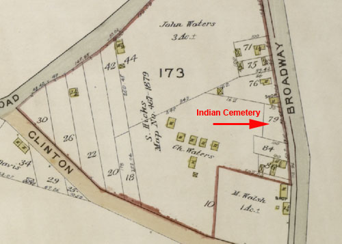
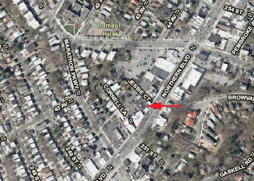
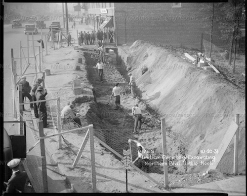
In 1931, the City of New York removed remains from a historic Native American cemetery in Little Neck, Queens, to allow for widening of Northern Boulevard between Douglaston Parkway and the Queens-Nassau county border.  The cemetery was the property of members of the Waters family of Little Neck, who were of Matinecock, Shinnecock, and Montauk ancestry.  James Waters (Chief Wild Pigeon), a leader in the Long Island Native American community, fought the removal.  Waters reportedly lived to the rear of the cemetery and had written about the site when it was surveyed by the Queens Topographical Bureau in 1919.

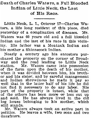
The 1919 survey of the cemetery identified 13 graves at the site. Only six headstones bore inscriptions, with dates on the headstones ranging from 1859 to 1904; all but one of these were for members of the Waters families.  One of the headstones recorded during the survey was for Charles Waters, who died in Oct. 1896 and whose death was reported in the Brooklyn Daily Eagle:

Brooklyn Daily Eagle, Oct 17 1896 p5

Opposition by Chief Wild Pigeon and others delayed removal of the graves for several years, but in October 1931 the disinterrment proceeded and the remains of about 30 individuals were subsequently reinterred in a plot in the cemetery of the nearby Zion Episcopal Church of Douglaston.  A boulder split in two, with a tree growing in between, marks the reburial site and is inscribed “Here rest the last of the Matinecoc.”  The site of the old Indian cemetery is now occupied by buildings that currently house a realty office and a restaurant.

The Indian Cemetery in 1913, located on the north side of Broadway (today's Northern Blvd) between Clinton Ave (Marathon Pkwy) and Old House Landing Rd (Little Neck Pkwy).
The Indian Cemetery in 1913, located on the north side of Broadway (today’s Northern Blvd) between Clinton Ave (Marathon Pkwy) and Old House Landing Rd (Little Neck Pkwy) (Hyde 1913)
The Indian Cemetery as surveyed in 1919 by Queens Topographical Bureau.
Present day view of the former Indian Cemetery site.
Present day view of the former Indian Cemetery site (NYCityMap)
Police inspect the Indian Cemetery in August 1931, a few months before its removal. (Daily News)
Excavation of the Indian Cemetery in October 1931 (NYC Municipal Archives)
The marker at the site of the plot where remains from the Indian Cemetery where reinterred at Zion Episcopal Churchyard, Douglaston (NYPL)

Sources:  Hyde’s 1913 Atlas of the Borough of Queens 3:Pl.21; Description of Private and Family Cemeteries in the Borough of Queens 42-44; “Queens Indians Agree to Removal of Bodies,” New York Times, April 24, 1927; “Indian Cemetery in Queens Excavated for Boulevard,” Brooklyn Standard Union Oct. 16, 1931; “Collection and Use of Indigenous Human Remains” (Sanders 2005), 141-143; NYCityMap.

Leverich Family Burial Ground

Entrance to the Leverich Family Burial Ground, Oct. 2010
Entrance to the Leverich Family Burial Ground, Oct. 2010 (Mary French)

This small family burial ground, hidden behind homes and businesses along Leverich St and 35th Ave, in Jackson Heights, Queens, is all that remains of the colonial homestead established by Caleb Leverich in the 17th century, in what was then the Trains Meadow section of old Newtown, Long Island.  Caleb was the son of English minister William Leverich, who immigrated to America in 1633.  The Leveriches became a prominent Newtown family and their old homestead, originally built by Caleb in 1670, stood nearby the burial ground until it burned down in 1909.

When the cemetery was first used is unknown.  Nineteenth-century historian James Riker recorded the 33 headstones that were present in the cemetery in 1842; the earliest was that of Caleb’s grandson John Leverich, who died in 1780.  The cemetery appears to have fallen out of use during the mid-1800s, around which time the Leverich homestead seems to have passed out of the family. Although the cemetery was abandoned as family members moved out of the area, the plot was excluded from the development that sprung up around it in the early 20th century.

City property records still identify the site as the Leverich Family Burial Ground, but there is nothing left to distinguish it as such.  All of the headstones have disappeared, there are no signs identifying it as a burial ground, and the site is tangled with brush and debris and strewn with rubbish. The cemetery has not been completely forgotten, however; many of the surrounding business- and homeowners know that the site is an old graveyard and some have attempted to clean up and protect the area.  When I visited the site in October 2010, the owner of one of the adjacent homes said that he and other neighbors had some of the debris hauled off and that they had installed the gate at the site’s entrance, which is in an alley behind neighboring businesses.  A neighborhood woman holds the key to the gate, and comes each day to feed the cats that seek shelter there. A family descendant, Tom Leverich, has researched and written about the burial ground, and local preservationists and community groups have also expressed concern for the site and an interest in preserving it.

The Leverich burial ground and family home on old Trains Meadow Road in the 19th century (Beers 1873)
The Leverich Family Burial Ground in 1903 (Hyde 1903)
Site of the Leverich Family Burial Ground today (NYCityMap)

View more photos of the Leverich Family Burial Ground

Update Oct 2017:  Leverich Family Burial Ground is now regularly cared for by neighborhood groups and used as a community space.  See photos of the revitalized site.

Sources:  “Leverich Family Burial Ground”; “Rev. William Leverich”; “Leverich (Leveridge) Family History and Geneaology”; The Annals of Newtown (Riker 1852), 350-354; Riker’s 1852 Map of Newtown; Beers 1873 Atlas of Long Island Pl. 52 ; Hyde’s 1903 Atlas of the Borough of Queens 2:Pl. 30); NYCityMapWoodside: A Historical Perspective, 1652-1994 (Catherine Gregory 1994) 23.

The New Burial Place Without the Gate of the City

Miller Plan of New York, 1695, showing the New Burial Place
Miller Plan of New York, 1695, showing the New Burial Place (Stokes 1915)

In 1656, officials of New Amsterdam considered the necessity to establish a new cemetery to replace The Old Graveyard that was located on the west side of Broadway around present-day Morris Street.  Exactly when the new graveyard was created is uncertain, but the 1686 Charter of the City of New York identified “the new burial place without the gate of the city” among a list of public accommodations belonging to the municipality.

This burial ground is shown on the 1695 Miller Plan of New York (above), situated on the west side of Broadway just beyond the city gates that were located on Wall Street.  In 1703 the city conveyed this parcel of land to Trinity Church, which had, in 1696, purchased land adjacent to the burial ground to establish their church.  The city transferred the graveyard to Trinity on the condition that it be used as the “publick Church yard and burial place of this Citty for Ever.” It is contained in what is today the northern portion of Trinity churchyard, between Wall Street and Pine Street.  When there was a proposal to extend Albany Street through the northern portion of Trinity churchyard in 1847, a report opposing the extension described the burial ground.

It is nearly a century older than the other sections of the yard. It was originally a valley, about thirty feet lower at its extreme depth than the present surface, and has undergone successive fillings, as the density of interments rendered it necessary, to raise the land until it reached the present surface, so that the earth now, to a depth of several feet below the original and thence to the present time of interment, is in truth filled with human remains . . . The bodies buried there were those of many thousand persons of several generations, and of all ages, sects and conditions, including a large number of the officers and soldiers of the Revolutionary War, who died whilst in British captivity; and almost every old family that is or ever was in this city, has friends, relatives or connections lying there.

Diagram of the New Burial Place at the time it was transferred to Trinity Cemetery (Hoffman 1862)
The northern section of present-day Trinity Churchyard contains the New Burial Place.
The northern section of present-day Trinity Churchyard contains the New Burial Place (NYCityMap)
The gravestone of five-year-old Richard Churcher, who died in 1681, is likely a remnant of the old burial ground. (Mary French)

Sources: The Iconography of Manhattan Island 1498-1909 (Stokes 1915) 1:Pl23); Records of New Amsterdam from 1653 to 1674 (City of New York 1897) 2:24-25; Charter of the City of New York, 1686, reprinted in The Memorial History of the City of New-York (Wilson 1892), 437-446; Ecclesiastical Records, State of New York 2:1134, 1180Minutes of the Common Council of the City of New York, 1675-1776 (City of New York 1905) 2:221Treatise Upon The Estate and Rights of the Corporation of the City of New York (Hoffman 1862) 2:176-177, Diag. 2; NYCityMap.

The Old Graveyard of New Amsterdam

The Old Graveyard shown on the Castello Plan of New Amsterdam in 1660
The Old Graveyard shown on the Castello Plan of New Amsterdam in 1660 (Stokes 1915)

The earliest known cemetery of colonial Manhattan was located on the west side of Broadway, around present-day Morris Street.  It is unclear when it was first established as a burial ground, but by 1656 it apparently had been in use for many years as it was referred to in Dutch records at that time as “The Old Graveyard, which is wholly in ruins.”  The Castello Plan of New Amsterdam in 1660 (above) shows the cemetery’s location along the west side of the main highway that later became known as Broadway.  The dilapidated condition of the Old Graveyard was cause for concern again in 1665, when city officials described it as “open and unfenced, so that hogs root in the same.”  In 1676, the city ordered that the cemetery be broken into lots and sold at auction.

What happened to the burials in the Old Graveyard after it was disposed of by the city is unknown.  It is possible that the graves were moved to the new burial place that had been established further north along Broadway at what is now the northern end of Trinity churchyard.  A more likely scenario (and one that is seen repeatedly for the city’s later public cemeteries) is that the graves were left in place and the area filled in before the land was reused.  Evidence of the Old Graveyard was discovered in the mid-1800s when workmen uncovered human remains while excavating cellars in the area.  Today, the high-rise office buildings that cover the site have obliterated all signs of this early colonial graveyard.

The Old Graveyard (here called “The Old Churchyard”) shown in relation to present-day Morris street on Stokes’ Map of Dutch Grants (Stokes 1916)
Approximate location of The Old Graveyard site in present day lower Manhattan.
Approximate location of former site of The Old Graveyard in present-day lower Manhattan (NYCityMap)

Sources: Records of New Amsterdam from 1653 to 1674 (City of New York 1897) 2:24-25, 5:253Minutes of the Common Council of the city of New York, 1675-1776 (City of New York 1905) 1:47Manual for Corporation of the City of New York for 1856 (Valentine 1856) 444-447; The Iconography of Manhattan Island, 1498-1909 (Stokes 1915-1916)1:Pl.10A2:221-222, Pl. 87; NYCityMap.