

In a 1934 article in the Leader-Observer, a longtime resident of Ozone Park described the area’s old community burying ground, remnants of which still exist at present-day Redding Street, Albert Road, and 149th Avenue in Queens:
In a little-known and seldom-visited corner of Ozone Park is one of the oldest burying grounds in New York . . . 15 years ago I often walked out there with my son, who was then a youngster, and we would wander about, reading the inscriptions on the stones and listening to the music of the birds that made the place their home. In those days there were only a very few houses near it . . . The plot even then had long been neglected, but without the usual sad results of neglect. Without man to spoil, nature ran riot . . . in the summer time the whole place was a glorious profusion of violets, lilies of the valley, tiger lilies, and even roses. To this little paradise had repaired the birds that had gradually been chased out of the more settled sections, so that in a few minutes the casual visitor would see ten or a dozen different varieties of brilliant multi-colored songsters . . . Taken all in all, it seemed to me then the most fitting resting place for those pioneers of old I had yet seen . . . The names on these ancient . . . stones were almost all Dutch, names that today are well known. Vanderveers lay there, and Van Wycks along with many others who gave meaning to the wilderness that once was this part of the country.
Today all is changed. I walked out there a few days ago, for the first time in about 10 years, and I was shocked. Since that time the Crossbay boulevard has been laid; a big cash-and-carry supermarket stands nearby; a development company has hedged in the little burying ground with raucously new brick houses. Where the birds used to sing by the old pipe line, autos now roar by in an unending stream on the Sunrise highway. But what shocked me most was the condition of the cemetery itself. The birds are gone, and the flowers. The shrubbery that once gave the moss-covered stones a decent privacy are now but a bedraggled collection of broken weeds. Even the stones are gone. Where they went I do not know . . . Of the several hundred monuments that were standing ten years ago, not more than a dozen remain . . .


This community cemetery was set aside as a burying ground about 1680 and was situated at the junction of two colonial highways—the Old South Road that crossed southern Queens from east to west, and the Road to Jamaica Bay, which later became Woodhaven Boulevard. Each neighboring family, among them the Ryders, Van Wicklens, Durlands, and Stoothoffs, was allotted a share in the burial ground at the time it was established. Known today as the Southside Burial Ground, the old graveyard has been referred to by a number of names over the years, including the Van Wicklen Cemetery, Aqueduct Cemetery, and Homestead Cemetery. The half-acre burial ground was used and remained intact until the housing boom and street construction that began in the 1920s destroyed much of it. About half of the cemetery was lost when 149th Avenue was extended through the southern portion of the site, and most of the monuments had disappeared by the 1930s.
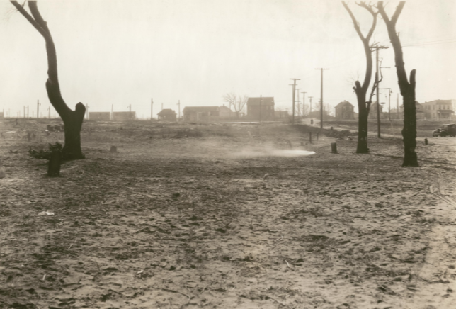
In December 1935, Long Island Daily Press reporter Sarah Wilford called the Southside cemetery the “most desolate in Queens,” after workmen chopped down most of the trees at the site and burned it over to clear it of vegetation. What remained of the cemetery gradually became a dumping ground. Concerned citizens of the area fought for decades to protect and preserve the burial ground, and today the NYC Parks department manages the site. Four gravestones still exist in the northern section of the old graveyard, which remains on the east side of Redding Street, between Albert Road and 149th Avenue. A remnant of the southern portion of the cemetery also exists in the park on the other side of 149th Avenue; although no stones are present in this section, it is distinguished by a chain-link fence that separates it from the adjacent ball field.


Sources: Description of Private and Family Cemeteries in the Borough of Queens (Powell & Meigs 1932), 54-57; Sidney’sMap of Twelve Miles around New-York, 1849; The Story of Woodhaven and Ozone Park (Seyfried 1985), 119; “Ozone Park Burial Ground Has Rich History,” Leader-Observer, Jan 4, 1996; “LIer Fights to Get Cemetery Removed from City Tax Rolls,” LI Press, July 2, 1972; “Historic Tombstones Found,” The Forum, Nov. 23, 1985; “South Side Cemetery Most Desolate in Queens,” LI Daily Press, Dec 12, 1935; “Crossbay Blvd Wipes Out Old Burying Ground,” Leader-Observer, Nov. 22, 1934; NYCityMap.


