The Ursuline Convent and Academy, East Morrisania, by Edward Valois, ca.1868; lithograph issued by George Schlegel (MCNY)
On April 11, 1892, the remains of 25 women were exhumed from a property along Westchester Avenue in East Morrisania and transported about five miles north for reburial in the Bedford Park section of the Bronx. In life, the women were members of a sisterhood rooted in 16th century Italy where Angela Merici founded the Ursuline Order, the first Roman Catholic institute dedicated to the education and spiritual development of young women. Extending their presence throughout Europe and into North America, the Ursulines established a strong identity as educators and founded communities and schools for the education of girls wherever they went. The Ursuline Convent and Academy at East Morrisania, established in 1855, was the first successful Ursuline community in New York—a previous attempt to establish an Ursuline convent in Manhattan in 1812 attracted no postulants, and disbanded in 1815.
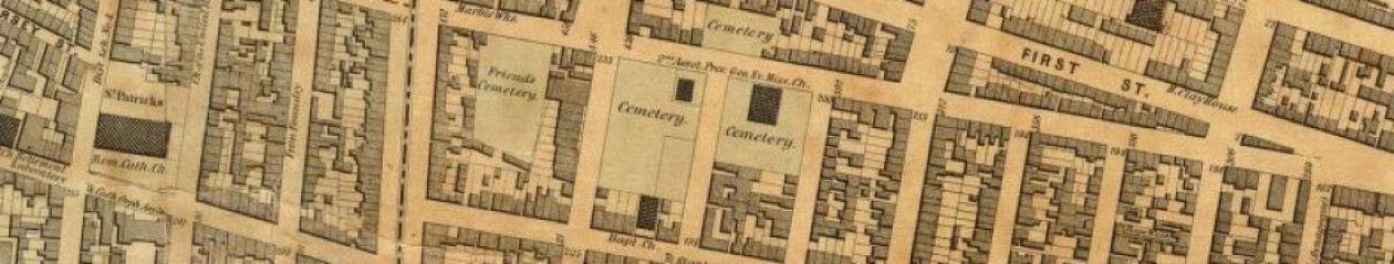
An 1887 map shows the East Morrisania Ursuline Convent and grounds, which extended from Jackson St to St. Ann’s Ave
The Ursulines thrived at East Morrisania, which was, in the mid-19th century, a rural suburb about nine miles north of the city. The Ursuline Convent and Academy was a picturesque locale, as described by a visitor who attended commencement exercises at the institution in 1862:
[The] Convent stands on an eminence which slopes gently down to a grassy plain and spacious grounds stretch around it on every side, allowing ample room for the pupils to exercise and recreate themselves in. On account of its elevated position it is visible for miles, forming quite a feature in the landscape, and imparting an air of antiquity and Catholicity to the scene.
By the 1870s, the Ursuline community at East Morrisania included about 40 professed nuns and 20 novices and postulants, and their girls’ academy attracted 70 pupils a year. Half of the community’s nuns taught at the academy, while the other sisters handled the convent’s domestic and administrative affairs. Nuns who died at the convent were interred in a burial ground on the community’s 8.5-acre property, situated on the north side of present-day Westchester Avenue between Jackson Street and St. Ann’s Avenue. It is not known exactly where within the property the burial ground was located.
This excerpt from an 1870 U.S. Census schedule for the Town of Morrisania is a partial list of the nuns living in the Ursuline Convent at that time.
Among those interred at the Ursuline burial ground at East Morrisania were Sister Agnes Boyce, native of Ireland, who died at the convent in 1874, aged 39; Sister Teresa Fuekenbusch, native of Prussia, died 1873, aged 35; Sister Florian Gilooly, from Wisconsin, died 1883, aged 28; and Sister Clotilda Lowenkamp, from Maryland, who died in 1890 at 30 years old. Tuberculosis was the most common cause of death among the young nuns laid to rest in the community’s burial ground.
The opening of the new Ursuline academy at Bedford Park is announced in this 1892 advertisement
As the area surrounding the Ursuline Convent at East Morrisania became more populated and industrialized, the community planned a move to a less-developed part of the Bronx. The Ursulines purchased a 10-acre property in the Bedford Park neighborhood in 1887 and moved the school and convent there in 1892. The East Morrisania property was subdivided and sold off to developers and burials exhumed from the site were reinterred in designated grounds at the Bedford Park location. By 1906, however, all burials from the Ursuline property at Bedford Park were transferred to a plot the order acquired at St. Raymond’s Cemetery. Although the Academy of Mount St. Ursula continues to operate today at Bedford Park, the convent there closed in 2007 and most of its members relocated to the Ursuline convent at New Rochelle.
Detail from a 1900 map depicting the Ursuline Convent and Academy at Bedford Park
Sources: Robinson’s 1887 Atlas of the City of New York, Vol 5, Pl 7; Sanborn’s 1900 Insurance Maps of the City of New York, Vol 13, Pl 38; Bodies in Transit Register X:1881-1894, Municipal Archives, City of New York; United States Census, 1870 & 1880, FamilySearch; Sadliers’ Catholic directories, 1873-1896; “Religious Reception,” Metropolitan Record, Feb 2, 1861; “St Joseph’s Ursuline Academy,” Metropolitan Record, July 26, 1862; “Academy of Mount St. Ursula” [Advertisement], Eastern State Journal (White Plains), Aug 27, 1892; St. Angela Merici and the Ursulines (O’Reilly 1880), 389-390; “What Lies Beneath: Cemeteries of the Bronx,” Bronx County Historical Society exhibit, Oct 2017; Cemeteries of the Bronx (Raftery 2016), 256-257; Ursulines of the Eastern Province
An 1836 map showing the public burial ground at 50th St and Fourth Ave
When New York City authorities decided to close the public burial ground at Washington Square in 1825, they selected a property “situate between the Third and Fourth Avenues, and between the 48th & 50th Streets” as the location for the new potter’s field. The site was considered well-suited for a public burial ground, since it was outside the populated city but only about a mile-and-a-half from both the state prison on the Hudson River and the almshouse at Bellevue. The grounds had recently been improved by the Commissioners of the Almshouse (who may have already been using it as burial ground), were enclosed by a “strong stone wall,” and required “no preparation for its immediate occupancy than that of a small tenement as a residence for the Keeper.” The site was quickly put into operation—the following year, 1,659 of the 4,973 people who died in the city were interred in the new potter’s field.
Located between today’s 50th and 48th streets and extending from Park to Lexington avenues, the remains of more than 60,000 people were laid to rest in the potter’s field over the next two decades, including approximately 600 cholera victims interred there during an outbreak in the summer of 1832. By the 1840s, the city was regularly receiving complaints about conditions at the 50th Street potter’s field. The New York Mirror called the site “disgraceful to the city of New-York—revolting to every properfeeling of the human heart, and unworthy of a Christian country.” In an 1845 report to the Board of Aldermen, the City Health Inspector described the situation at the site, where “bodies have not been regularly or decently interred in graves, but great pits have been dug in which a large number of bodies have been deposited; and when filled, have been covered over slightly with earth, allowing the most offensive and pernicious exhalations to fill the atmosphere, to such an extent as to endanger the health of the whole neighborhood.” Though a site on Randall’s Island was selected for a new potter’s field in 1843, many of the city’s indigent and unknown continued to be buried at the 50th Street site until the late 1840s.
Excerpt from a New York Times report on the extension of 49th street through the cemetery in 1853
During the 1850s, the defunct public burial ground at 50th Street was continually disturbed by the city’s northward expansion. A section of the grounds at Fourth Avenue (today’s Park Avenue) and 48th Street transferred to a private owner, necessitating the removal of some 2,000 bodies to another part of the field. Property owners in the vicinity petitioned the city to convert the site into a public park, as it had done with the previous public burial ground at Washington Square, but the request was refused by the city council, who voted to open 49th Street through the site. The city cut the street through in 1853, leaving “the bones of its unfortunate citizens” scattered about, according to the Evening Post.
A view of the “desecrated” burial ground in April 1857, from Leslie’s Illustrated Newspaper
Thousands of bodies were again disinterred and moved to another area of the grounds in 1857, when Fourth Avenue and 50th Street were graded along the site’s western and northern boundaries. This work left the old potter’s field in shambles—the Herald described stacks of coffins lining the sidewalks and a rough fence erected on the southwest corner of Fourth Avenue and 50th Street to “prevent the pile of coffins tumbling from their somewhat higher position to the level of the newly made sidewalk.” Exposed coffins were visible in the soil banks along the graded streets, “with the hairless skulls of the poor pauper occupants staring the passerby full in the face.”
Another sketch from Leslie’s Illustrated, depicting conditions at the site in April 1857
In April 1857, the City Health Inspector recommended removal of remains from the 50th Street Potter’s Field, noting that the “general appearance of the ground was disgusting,” with hundreds of human bones exposed and “many people gathered there on Sundays and amused themselves by poking out the skulls and bones.” In 1858-59, the remains were disinterred and transferred to the potter’s field then in operation on Ward’s Island. The 50th Street potter’s field is notable as the last potter’s field established on Manhattan Island; much of the site is occupied today by the Waldorf-Astoria Hotel, built in 1929-31.
The Waldorf-Astoria Hotel and other buildings are shown on the site of the former burial ground in this 1955 mapA 2016 aerial view; red lines indicate approximate boundaries of the 50th Street public burial ground site
Sources: Colton’s 1836Map Of The City and County Of New-York; Bromley’s 1955 Manhattan Land Book of the City of New York, Pl 78; Minutes of the Common Council of the City of New York, 1784-1831 (City of New York 1917), 14:306-308; “Proceedings of the Common Council,” New York Spectator, Mar 6, 1827; [City Inspector’s Report of Deaths], New York Evening Post Jul 17, 1832; “Board of Health,” New York Spectator, Jul 26, 1832; “Potter’s Field,” New York Mirror May 30 1840; Documents of the Board of Aldermen of the City of New York Vol 11, 1845, 681-682; “Burials in Cities,” New York Daily Tribune May 30, 1848; “Twelfth Ward Street Opening,” New York Herald, Mar 26, 1850; “Old Potter’s Field,” New York Evening Post, May 30, 1853; “The Old Potter’s Field,” New York Times, May 31, 1853; “The Old Potter’s Field,” New York Herald, Mar 15, 1857; “Public Health—Potter’s Field Again,” New York Daily Tribune, Apr 7, 1857; “Exhumation of Bodies at the Potter’s Field,” New York Evening Post, Jun 8, 1858; “Potter’s Field,” Frank Leslie’s Illustrated Newspaper,Jun 19, 1858; “The News,” New York Herald, Jun 7, 1859
Detail of Bridges 1811 map of the city, showing Greenwich village; approximate boundaries of the potter’s field are indicated in red
In April 1797, New York City authorities decided to purchase a piece of property “bounded on the Road leading from the Bowery Lane at the two Mile Stone to Greenwich” to replace the public burial ground then in use at Madison Square Park. The property was seen by many as a good choice for the new potter’s field—it was in a rural area north of the populated city but a convenient distance to the Almshouse in City Hall Park, to the public hospital at Bellevue on the East River, and to the new state prison just west on the Hudson River. One group, however, was incensed by the plan—affluent New Yorkers who had country retreats in Greenwich village. The burial ground would not only abut the suburban homes of many of the city’s elite, but it was contiguous to the only road leading westward from the Bowery turnpike to Greenwich, so they and their fashionable visitors would have to suffer the slow-moving wagons carrying bodies to the site.
Fifty-seven owners of residences in the vicinity, including Alexander Hamilton, immediately sent a letter of protest to the Common Council, stating that the burial ground would “lie in the neighborhood of a number of Citizens who have at great expense erected dwellings on the adjacent lots for the health and accommodation of their families during the summer season, and who, if the above design be carried into execution, must either abandon their seats or submit to the disagreeable sensations arising from an unavoidable view of and close situation to a burial place of this description destined for the victims of contagion.” The petitioners offered to buy another piece of land in exchange for the planned site, but their proposal was denied. The city proceeded with preparing the new burial ground, bounded by Greenwich Lane on the north, Fourth street on the south, Wooster Street on the east, and Minetta Creek (which ran southwest from the foot of Fifth Avenue to the corner of MacDougal and Fourth streets) on the west. This property forms approximately the eastern two-thirds of today’s Washington Square Park.
An 1817 survey of the potter’s field, showing the Scotch Presbyterian burial grounds at the northeast corner (Geismar 2005)
By November 1797, the new burial public burial ground was ready—fenced with “good posts and rails” and planted with trees—and the city ordered the keeper to commence interments there instead of at the old Potter’s Field at Madison Square Park. The keeper, who lived in a house in the northeast corner of the seven-acre site, dug graves, maintained the grounds, and performed another important function—protecting the cemetery from grave robbers. During the 18th and 19th centuries, medical students and physicians were in desperate need of cadavers for their training and research; with no mechanism in place to supply them with fresh corpses, they resorted to body snatching—a crime so common that almost every prominent physician in the city confessed to having taken part. They often pilfered remains from the city’s most vulnerable graveyards—the African burial grounds and potter’s fields, where their raids were less likely to arouse public outrage.
Excerpt from the New York Evening Post report of an 1824 attempt to steal bodies from potter’s field
John McKenzie, Keeper of the Potters Field in 1808, was dismissed from the position when he confessed to “conniving at the disinterment and taking away of dead bodies” from the burial ground. One of his successors in the position, William Schureman, was a more faithful servant to the dead—at about 3 o’clock on an April morning in 1824, Schureman “suspected that some person had entered the field for the purpose of removing the dead, and after sending for two watchmen, and calling his faithful dog, he went to ascertain the fact.” His suspicions were confirmed when he arrived at a burial pit containing about 10 coffins that had been uncovered; when the person concealed in the grave refused to show himself, Schureman sent his dog into the pit. Instantly, “a tall, stout fellow made his appearance, and took to his heels across the field.” The grave robber was eventually secured by the watchmen and sentenced to six months in prison. Reporting the story, the New York Evening Post cautioned, “the young gentlemen attending the medical school of this city, will take warning by this man’s fate. They may rest assured that the keeper of Pottersfield will do his duty and public justice will be executed upon any man, whatever may be his condition in life, who is found violating the law and the decency of Christian burial.”
Headstone of James Jackson, a 1799 victim of yellow fever; the headstone was found in Washington Sq Park in 2009 (New York Times)
The potter’s field was a burial place not only of “strangers and paupers,” but citizens, rich and poor alike, who died of yellow fever. In the summer of 1798, the disease returned to the city in such proportions it became known as the Great Epidemic; of the 2,000 New Yorkers who perished, about 660 were buried in the potter’s field. The following year, and in subsequent outbreaks, churches were forbidden from burying yellow fever victims in their burial grounds; all those succumbing to it were interred in the potter’s field. In an address delivered to the New-York Historical Society in 1857, John W. Francis describes the potter’s field at Washington Square as “our Golgotha during the dreadful visitations of the Yellow Fever in 1797, 1798, 1801, and 1803…many a victim of the pestilence, of prominent celebrity, was consigned to that final resting-place on earth, regardless of his massive gains, or his public services.”
In addition to serving as burial ground for the indigent, the unknown, and those dying of contagious diseases, the potter’s field was the location of a number of church plots, which lined the burial ground’s eastern edge. Among these church plots were several at the northeastern corner of the potter’s field belonging to congregations of the Scotch Presbyterian Church, and two 50-foot-square plots set aside for the African Methodist Episcopal Zion Church and Asbury African Church.
By the 1820s, some 20,000 bodies had been laid to rest in the potter’s field and the area surrounding the burial ground—once farm fields and country estates—had transformed into a thriving suburb of the city. Houses and shops lined the blocks immediately south of the burial ground; wells were dug, pumps installed, and streets regulated. “The present Pottersfield is nearly filled, and by Spring it will be necessary to remove it to some other place,” the city council reported in December 1824; a month later, they announced, “the time has arrived when interments should be interdicted in a part of Our City so rapidly improving as that in the vicinity of the present Pottersfield.” In 1825, the burial ground was closed and ordered filled and leveled. The city acquired additional land on the west side of the potter’s field to give the property a uniform shape, and in 1828 the site was described as “a beautiful public square, called Washington Square, which is also used as a military parade ground.” By 1878 it was a public park.
Map showing location of burial vault found at the northeastern corner of the park in 1965; believed to be part of the Scotch Presbyterian burial grounds
When the city was in the process of creating a public square from the burial ground, the Common Council declared “it is not the intention of this Board to disturb any of the graves within these grounds nor will there be any absolute necessity for such a measure.” They acknowledged that among those buried there were “many connected with our most respectable families” and said they would not think of “disturbing the numerous remains deposited there.” Despite these noble intentions, remains of those resting under Washington Square Park have been disturbed a number of times over the years.
Workmen digging the foundation for the park’s iconic Washington Memorial Arch at the Fifth Avenue entrance in 1890 unearthed coffins, skeletons, and headstones, two bearing the date 1803. In 1941, the New York Times reported more “grim human relics of the eighteenth and nineteenth century” were encountered by WPA laborers who found human remains during excavations for a sewer on the north side of the park. During utility excavations at the northeastern corner of the park in 1965, Con Edison workmen broke through the domed roof of an underground burial vault containing several coffins and “at least 25 skeletons;” this likely was part of the burial grounds of the Scotch Presbyterian Church.
An intact burial uncovered in the park in 2008 (Geismar 2009)
And remains representing at least 31 individuals, including 16 intact graves, were discovered during archaeological work connected with renovations at the park between 2009 and 2013. Also discovered during these excavations was a beautifully-engraved brownstone marker found in the southwest quadrant of the park. “Here lies the body of James Jackson,” the inscription on the three-foot-tall headstone says, “who departed this life the 22nd day of September 1799 aged 28 years native of the county of Kildare Ireland.” Though no human remains were found associated with the headstone, research confirmed that Jackson was a victim of yellow fever and that’s how he—and his finely-made headstone—came to rest in the potter’s field.
Update June 2021: Human remains uncovered during construction at Washington Square Park between 2008 and 2017 were reburied inside the park in March 2021. The partial remains were placed in a wooden box and buried five feet below grade in a planting bed near the Sullivan Street entrance. The reburial site is marked with an engraved paver near the Sullivan Street and Washington Square Park South entrance.
A 2016 aerial view of Washington Square Park (NYCityMap)Site where human remains were reburied at Washington Sq Park in 2021 (Mary French)Commemorative marker at the reburial site in Washington Sq Park (Mary French)
Sources: Bridges 1811 Map of the city of New York and island of Manhattan, as laid out by the commissioners appointed by the legislature, April 3d, 1807; Minutes of the Common Council of the City of New York, 1784-1831 (City of New York 1917), 2:336, 339, 348, 351, 403-404, 512; 4:525; 5:59, 383, 390; 11:575; 14:22, 306-308;15:160, 234, 748; 16:48-50; The Iconography of Manhattan Island: 1498-1909 (Stokes 1915-1928), 5:1340, 1673; An Account of the Malignant Fever, Lately Prevalent in New York (Hardie 1799); Old New York; or Reminiscences of the Past Sixty Years (Francis 1858), 24-25; Historic New York (Goodwin et al 1899), 232, 316; It Happened on Washington Square (Folpe 2002), 55-69; Around Washington Square (Harris 2003), 5-11; Bellevue: Three Centuries of Medicine and Mayhem at America’s Most Storied Hospital (Oshinsky 2016), 29-32; “Resurrectionists,” New York Evening Post, May 20, 1824; “Skeletons in the Way” New York Times, May 13, 1890; “Unearth a Potter’s Field,”New York Times,Mar 13, 1941; “Skeletons Found in Washington Sq.,” New York Times, Aug 2 1965, “Bones to be Left in Washington Sq.” New York Times, Aug 3 1965; “Gravestone from 1799 is Found in Washington Square Park,” New York Times, Oct 28, 2009; Washington Square Park: Phase 1A Archaeological Assessment(Geismar 2005); Washington Square Park: Phase 1 Construction Field Testing Report (Geismar 2009); Washington Square Park: Phase 2 Construction Field Testing Report (Geismar 2012); Washington Square Park: Phase 3 Construction Field Testing Report (Geismar 2013); “200-Year-Old Human Remains are Reburied in Washington Square Park,” Village Sun, Mar 3, 2021
The public burial ground, or potters field, at the junction of Post and Bloomingdale roads, now Madison Square Park (Randel 1820)
New York City’s municipal Almshouse was under siege in the 1790s. The city was in a growth spurt that would double its population to 60,000 by the end of the decade; at the same time, it was ravaged by annual outbreaks of yellow fever. Though yellow fever endangered all New Yorkers (750 fell to it in 1795), the city’s poor were most susceptible to the disease. The rising number of indigent residents and ailing poor placed a strain on the crumbling, sixty-year-old Almshouse, which housed close to 800 people by 1795.
In response to this situation, the city opened a new, larger almshouse just north of the first Almshouse in City Hall Park and established a yellow fever hospital at Bellevue, along the East River north of the settled city. The city also found a new burial place for the poor, interred in grounds adjacent to the Almshouse since the 1750s. In August 1794, the Common Council ordered that the “Triangular Piece of Ground at the junction of the Post & Bloomingdale Roads be appropriated to the use of the Alms House for a Burying Ground.” A month later, the council directed that the hospital at Bellevue be permitted to bury their dead at this same site. The site became a graveyard for interment of paupers, the unknown, and those dying of contagious diseases.
Randel’s 1820 map shows the potter’s field located at the triangular piece of ground formed by the junction of Bloomingdale and Post Roads.
The public burial ground at Post and Bloomingdale roads—the vicinity of present-day 26th Street between Fifth and Madison avenues—was used for just three years. Opposition to transporting the dead on the busy roads leading to the potter’s field compelled the city to discontinue its use in May 1797 and open a new public burial ground at what is now Washington Square Park. The abandoned potter’s field at Post and Bloomingdale roads transferred to the United States government for an arsenal in 1806; later it was the location of the House of Refuge for juvenile delinquents. In 1847, the site was leveled, sodded, and enclosed to create Madison Square Park.
The site’s history as a potters field was recognized even after it was converted into an arsenal, as evidenced in this 1809 notice of a deserted soldier.
Though the burial ground was used only for a short period, hundreds of people likely were interred there during this calamitous time. Some burials were disinterred when the U.S. government built a powder-and-shot magazine at the site; in 1808, L’Oracle (one of the city’s early 19th century newspapers)reported that “persons employed in digging the foundation of the Magazine in the Old Potter’s Field daily dig up coffins and dead bodies which are disposed of in the most indecent and disrespectful manner.” On several occasions in the early 20th century, construction workers uncovered human remains at the north end of the park during excavations for sewer lines and water pipes. Burials may still be present beneath the park.
Excerpt of 1930 New York Times article reporting discovery of remains of the potter’s field in Madison Square Park.Map of Madison Square Park (NYCityMap)
Sources: Randel’s 1820 Farm Maps, No. 14; Minutes of the Common Council of the City of New York, 1784-1831 (City of New York 1917), 2:92, 102, 351, 365; Manual of the Corporation of the City of New York (Valentine 1856), 465; The Iconography of Manhattan Island: 1498-1909 (Stokes 1915-1928), 5:1313, 1474, 1494; Bellevue: Three Centuries of Medicine and Mayhem at America’s Most Storied Hospital (Oshinsky 2016), 11-28; “Twenty Dollars Reward” [Notice], New York Evening Post, Apr 8 1809; “Park Once Potter’s Field, New York Times, July 11, 1908; “Unearth Skeleton in Park,” New York Times, Sep 11, 1930.
A 19th-century depiction of the first Almshouse (1736-1797) now the site of City Hall (NYPL)
In the early 1730s, the growing city of New York—then about 9,000 people clustered at the south end of Manhattan—was grappling with the problem of poverty. The “Number and Continual Increase of the Poor within this City is very great and Exceeding burthensome to the Inhabitants thereof,” the Common Council reported in 1734, necessitating construction of a municipal poorhouse, or almshouse. The Almshouse opened in 1736 on the Commons, a triangular piece of communal pastureland at what was then the northern edge of the city. The Almshouse served as a shelter for the poor who were unable to work due to old age or illness and a workhouse/house of corrections for impoverished people considered able to work but “living Idly and unimployed,” as well as “all disorderly persons, parents of Bastard Children, Beggars, Servants running away or otherwise misbehaving themselves, Trespassers, Rogues, [and] Vagabonds.”
Maerschalck’s 1755 map shows the “Poor House,” or Almshouse, situated in the Commons
Along with housing the sick, impoverished widows, and orphans, the Almshouse put the idle back to work and incarcerated criminals. Inmates (the term used to refer to residents of all public institutions during this time period) received clothing and followed strict daily schedules consisting of meals, prayer, and work (carding wool, making buttons, shredding old rope for reuse, or raising garden crops). In 1785, the Almshouse had 301 inmates—63 men, 133 women, 50 boys, 49 girls, and “2 Black Men & 4 Black Women.” Stays ranged from a day up to the death of an inmate.
Over the course of the 18th century, the Commons became the site of a number of other public buildings including the Gaol, or Jail, completed in 1759, east of the Almshouse; the Bridewell, a prison built in 1775 west of the Almshouse; and the Barracks, four structures constructed at the north end of the Commons beginning in 1757 to house soldiers. Areas surrounding these buildings were used as institutional burial grounds. A fenced burial place for deceased Almshouse inmates was established in 1757 “to the Eastward of and adjoining to the fence of the said Work House, of the Length of two Boards.” Apparently this graveyard was filled by 1785, when the Keeper of the Almshouse requested new grounds for this purpose and the city ordered that vacant ground “in the rear of the Barracks” be used for interment of those dying in the Almshouse and the Bridewell.
The Almshouse and other structures in the Commons, 1776-96 (Bankoff & Loorya 2008)
In 1797, the city built a new almshouse just north of the first almshouse, which was demolished at that time. In 1803, City Hall was erected on the site the first Almshouse, and the Commons began to transform into today’s City Hall Park, located just south of Chambers Street, between Broadway and Centre streets. In 1816, the poor were relocated to a complex at Bellevue and the second Almshouse building was used a cultural center until it was demolished in 1857; it is now the site of Tweed Courthouse. As the Commons changed from an area of social welfare, penal institutions, and military housing to the seat of local government, the Almshouse burial grounds vanished beneath City Hall Park. Long thought to have been obliterated by two centuries of construction activity, the forgotten burial grounds reappeared during archaeological work connected with recent renovation projects.
Map of City Hall Park, including City Hall and Tweed Courthouse (NYCityMap)
More than 50 graves, and disturbed human remains representing at least 200 more individuals, have been found in the north section of City Hall Park since the late 1990s and are believed to be associated with the first Almshouse and the Commons’ other 18th-century institutions. Intact burials were left in place during the excavations, protected to prevent disturbance and covered over again; they rest under the lawns and paved areas near City Hall and Tweed Courthouse. Disturbed burials and fragmentary human remains were collected, analyzed, and eventually reburied in the northeastern corner of the park near Chambers and Centre streets.
Analysis of the skeletal remains suggests people consistent with the Almshouse population—most appear to be of European ancestry; males and females, young and old adults, infants and children are all represented; and many show the traces of lives spent in hard work, poorly healed fractures, and pathologies caused by illness or poor nutrition. These discoveries provide a view of an overlooked segment of society—those unfortunate and unruly early New Yorkers laid to rest in the Almshouse burial grounds, souls no longer forgotten.
Human remains from the Almshouse burial grounds discovered in the northeast corner of City Hall Park, 1999 (Bankoff & Loorya 2008)Commemorative marker in a lawn at the northeast corner of City Hall Park, where human remains from the Almshouse burial grounds were reinterred (Mary French)
Sources:Maerschalck’s 1755 Plan of the City of New York from an Actual Survey; Minutes of the Common Council of the City of New York, 1675-1776 (City of New York 1905), 4:240-241, 308-309; 6:85-86; Minutes of the Common Council of the City of New York, 1784-1831 (City of New York 1917), 1:151, 158, 184-185; Tweed Courthouse Archeological Survey and Data Retrieval Investigations (Hartgen 2003); The History and Archaeology of City Hall Park(Bankoff & Loorya 2008); “Colonial-Era Human Remains Are Unearthed Near City Hall,” New York Times, Oct 25, 1998; “Ghosts From a Long-Ago Poorhouse in City Hall Park,” New York Times, Jun 11, 1999; “Under City Hall Park,” Archaeology Magazine, Feb 25, 2000; “The City Hall Park Project, Archaeology Magazine, Feb 12, 2007; Touring Gotham’s Archaeological Past (Wall & Cantwell 2004), 46-49; “Bones From Historic Downtown Burial Grounds Reinterred in City Hall Park,” DNA Info, Nov 12, 2013; History of Poverty & Homelessness in NYC; Historical Marker Database.